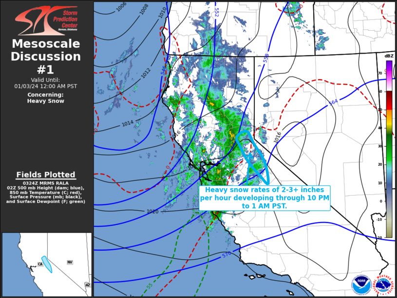
   Mesoscale Discussion 0001
   NWS Storm Prediction Center Norman OK
   0926 PM CST Tue Jan 02 2024

   Areas affected...the Sierra Nevada...from west of Tahoe into areas
   southeast of Yosemite

   Concerning...Heavy snow

   Valid 030326Z - 030800Z

   SUMMARY...Heavy snow rates in excess of 2 inches per hour may begin
   impacting the I-80 corridor west of Tahoe by 9-10 PM PST, if not
   earlier, before developing southward along the western slopes of the
   Sierra Nevada, across and southeast of Yosemite by midnight-1 AM
   PST.

   DISCUSSION...Cloud tops have been cooling the past few hours, inland
   of the San Francisco Bay area toward the Sierra Nevada to the west
   of Tahoe.  This is occurring downstream of a vigorous short wave
   trough, which is forecast to continue gradually pivoting across and
   inland of the central California coast through 06-09Z., accompanied
   by considerable further strengthening of large-scale ascent.  Models
   indicate that strongest lift will focus along a frontal zone already
   in the process of advancing inland, south/east of the Bay area and
   into the northern Sierra Nevada, and within an increasing upslope
   flow component across the western slopes of the northern into
   southern Sierra Nevada by late evening.

   Coupled with saturating thermodynanmic profiles, including
   precipitable water in excess of .4 to .5 inches, strengthening lift
   through through mid-levels with favorable cold temperatures for
   large dendritic ice crystal growth (roughly between 700-600 mb in
   forecast soundings) appears likely to yield intensifying snow rates.
    By 05-06Z, if not before, guidance generally indicates that this
   may include rates in excess of 2 inches per hour near the Interstate
   80 corridor, where cold advection may result in snow levels falling
   to near or below 4000 feet.

   As the strengthening lift develops southward along the mountains
   into and southeast of the Yosemite vicinity through 08-09Z, snow
   levels are likely to be higher (on the order of 4500 to 5000+ feet),
   at least initially, before gradually falling overnight.  However,
   somewhat higher moisture content may support heavier peak rates
   approaching or exceeding 3 inches per hour.

   ..Kerr.. 01/03/2024

   ...Please see www.spc.noaa.gov for graphic product...

   ATTN...WFO...REV...HNX...STO...

   LAT...LON   39282034 38832002 38131950 37361936 37671975 38162027
               38772070 39082082 39282034
|


 @NWSSPC