|
| Mesoscale Discussion 3 |
|
< Previous MD Next MD >
|
|
Mesoscale Discussion 0003
NWS Storm Prediction Center Norman OK
0228 AM CST Sat Jan 06 2024
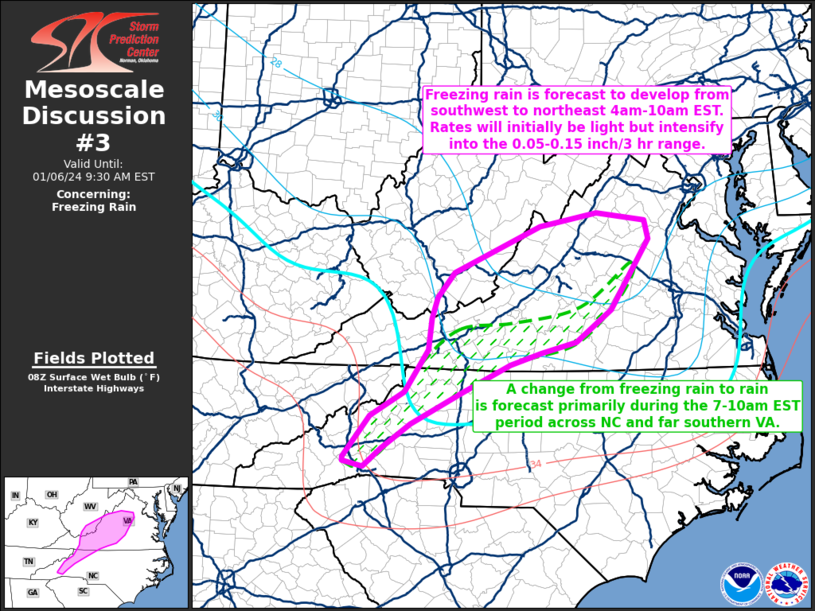
Areas affected...western NC...western into central VA...far
southeastern WV
Concerning...Freezing rain
Valid 060828Z - 061430Z
SUMMARY...Freezing rain is forecast to develop from southwest to
northeast through 10am EST. Freezing rain rates will initially be
light as the atmospheric column moistens, but rates are forecast to
intensify into the 0.05-0.15 inch/3 hour range. A transition from
freezing rain to rain is forecast to occur over western NC into
southern portions of western VA primarily during the 7-10am EST
period.
DISCUSSION...Radar mosaic as of 325am EST shows an extensive
precipitation shield across GA into western SC and moving northeast
into the southern Appalachians. This precipitation is in response
to a mid-level shortwave trough moving northeast across the lower MS
Valley early this morning. This mid-level feature is forecast to
move into the southern Appalachians during the morning. Strong
low-level warm-air advection and moistening via a warm conveyor belt
are acting to enhance large-scale lift and contribute to a
moistening atmospheric column during the pre-dawn hours across
western NC into western/central VA.
The latest ensemble model guidance (i.e., HREF, SREF) show agreement
in depicting a swath of precipitation spreading north-northeast with
hourly rates generally in the 0.05-0.15 inch range. Forecast
soundings indicate thermal profiles supporting freezing rain as the
primary precipitation type from western NC northward through much of
western VA and adjacent southeastern WV. However, this shallow
sub-freezing layer near the surface is forecast to slowly erode
across western NC and southern parts of western VA as surface
temperatures warm to 32 deg F or higher, primarily during the 7-10am
EST period. Farther north, some intermittent mixing of freezing
rain and sleet is possible especially on the northern periphery of
the discussion area (i.e., northwestern parts of VA).
..Smith.. 01/06/2024
...Please see www.spc.noaa.gov for graphic product...
ATTN...WFO...AKQ...LWX...RNK...RLX...GSP...
LAT...LON 37327841 36917897 36777954 36628003 36278078 35868160
35548205 35308234 35378265 35428265 35958223 36278170
36808133 37218127 37488119 37808091 38397955 38557864
38467786 38217781 37327841
|
|
Top/All Mesoscale Discussions/Forecast Products/Home
|
|


 @NWSSPC