|
| Mesoscale Discussion 8 |
|
< Previous MD Next MD >
|
|
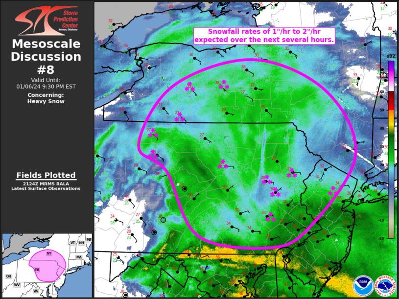
   Mesoscale Discussion 0008
   NWS Storm Prediction Center Norman OK
   0327 PM CST Sat Jan 06 2024

   Areas affected...Central/Eastern PA...Southern NY...Northern NJ

   Concerning...Heavy snow

   Valid 062127Z - 070230Z

   SUMMARY...Snowfall rates around 1"/hr appear probable across this
   region, with some potential for 2"/hr rates,

   DISCUSSION...A shortwave trough continues to progress quickly
   northeastward across WV and VA. A broad precipitation field covers
   much of the northern Mid-Atlantic states as well as NY, supported by
   moderate to strong low-level warm advection ahead of the wave.
   Occasionally heavy snow has been noted across the region over the
   past few hours, particularly across western and southern PA, where
   the low-level warm advection/frontogenesis is being augmented by
   large-scale forcing for ascent near the shortwave trough. This
   general trend is expected to continue over the next several hours,
   with heavy snow shifting from western/central PA into
   western/southern NY. Snowfall rates around 1"/hr appear probable
   across this region, with some potential for 2"/hr rates,
   particularly just north of the leading edge of the mid-level dry
   air.

   ..Mosier.. 01/06/2024

   ...Please see www.spc.noaa.gov for graphic product...

   ATTN...WFO...OKX...ALY...PHI...BGM...BUF...CTP...

   LAT...LON   40047754 41157827 41587893 42637815 43097628 42547458
               41407392 40157503 39827595 40047754
|
|
Top/All Mesoscale Discussions/Forecast Products/Home
|
|


 @NWSSPC