|
| Mesoscale Discussion 30 |
|
< Previous MD Next MD >
|
|
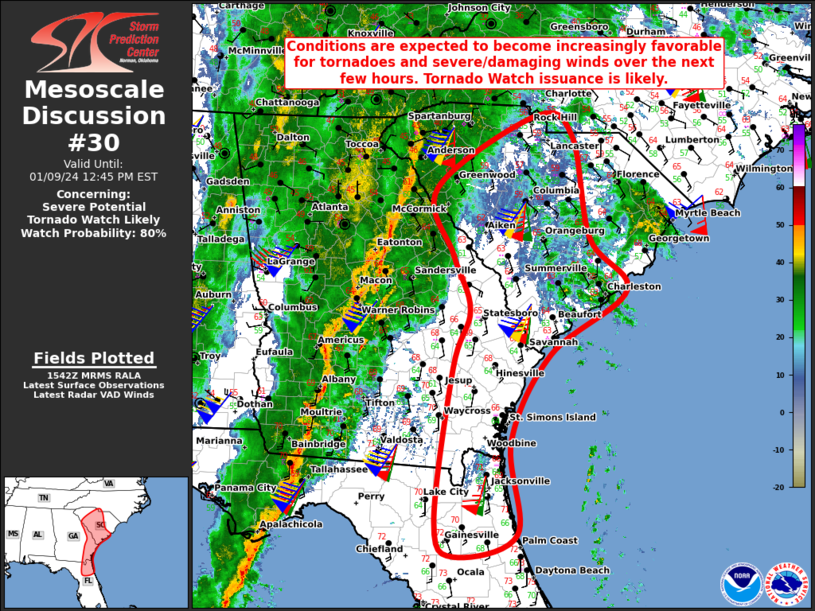
   Mesoscale Discussion 0030
   NWS Storm Prediction Center Norman OK
   0945 AM CST Tue Jan 09 2024

   Areas affected...Portions of north FL...coastal/eastern GA...much of
   SC...and extreme south-central NC

   Concerning...Severe potential...Tornado Watch likely

   Valid 091545Z - 091745Z

   Probability of Watch Issuance...80 percent

   SUMMARY...Conditions are expected to become increasingly favorable
   for tornadoes and severe/damaging winds over the next couple of
   hours. Tornado Watch issuance is likely.

   DISCUSSION...A broken line of convection extends from northeast GA
   to the FL Panhandle along/near a surface cold front. A powerful
   upper cyclone is centered over the mid MS Valley this morning, with
   associated 60-80+ kt southerly low-level jet rapidly advecting
   moisture northward ahead of the line. Various recent RAP/NAM
   forecast soundings across north FL into coastal/eastern GA and much
   of SC suggest that it will take at least 62-63F surface dewpoints
   amid modest daytime heating to aid weak boundary-layer
   destabilization and the potential for surface-based thunderstorms.
   Latest surface observations indicate that sufficient low-level
   moisture is already in place as far north as central GA/SC.

   Current expectations are that this continued low-level warm/moist
   advection will likely support a severe threat as far north as parts
   of upstate SC and towards Charlotte NC. Area VWPs ahead of the
   ongoing QLCS show low-level flow quickly strengthening to 60-70+ kt
   above 1 km, with ample low-level shear available to support updraft
   rotation and embedded tornadic circulations within the line.
   Severe/damaging downdraft winds of 60-75 mph also appear likely
   given the strength of the low-level flow. With the severe potential
   likely to increase across this region over the next few hours,
   Tornado Watch issuance is likely.

   ..Gleason/Hart.. 01/09/2024

   ...Please see www.spc.noaa.gov for graphic product...

   ATTN...WFO...CHS...CAE...GSP...JAX...

   LAT...LON   29908244 31848219 32578194 33248219 34118244 35028094
               34778040 33478014 32807960 32018073 30918133 29738123
               29458216 29908244
|
|
Top/All Mesoscale Discussions/Forecast Products/Home
|
|


 @NWSSPC