|
| Mesoscale Discussion 72 |
|
< Previous MD Next MD >
|

|
   Mesoscale Discussion 0072
   NWS Storm Prediction Center Norman OK
   0232 AM CST Tue Jan 16 2024

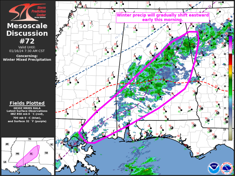
   Areas affected...Southern MS into central/southern AL and a small
   part of northwest GA

   Concerning...Winter mixed precipitation

   Valid 160832Z - 161330Z

   SUMMARY...Winter precipitation will shift eastward early this
   morning. Embedded heavier showers of sleet or freezing rain will be
   possible.

   DISCUSSION...Early this morning, a broad area of post-frontal
   precipitation is ongoing from southern MS into central AL. This area
   of precipitation will continue to spread eastward this morning in
   conjunction with the front and a weak eastward-moving frontal wave
   across the northeast Gulf of Mexico. Weak but nonzero MUCAPE (as
   noted in the 06Z BMX sounding) will continue to support fast-moving
   showers with briefly moderate precip rates embedded in the broader
   light precipitation shield.

   A substantial warm nose aloft (also noted on the 06Z BMX sounding)
   atop a shallow subfreezing layer at the surface will continue to
   support freezing rain and sleet as the primary winter precipitation
   types. Strong low-level cold advection will continue to push the
   surface freezing line southeastward with time, with a transition to
   freezing rain expected into parts of south-central AL, southern MS,
   and northwest GA, where temperatures are currently above 32F.
   Deepening cold air beneath the warm nose will support primarily
   sleet across the northwest portion of the precipitation shield. Some
   oscillation between freezing rain and sleet is possible within the
   transition zone.

   ..Dean.. 01/16/2024

   ...Please see www.spc.noaa.gov for graphic product...

   ATTN...WFO...FFC...BMX...MOB...JAN...LIX...

   LAT...LON   31278928 31908844 32538767 33008710 33768617 34158535
               34148498 33808495 33068514 32898522 32478535 32128557
               31428669 30828792 30178932 30178962 30288978 30528998
               30748983 31278928
|
|
Top/All Mesoscale Discussions/Forecast Products/Home
|
|


