|
| Mesoscale Discussion 74 |
|
< Previous MD Next MD >
|
|
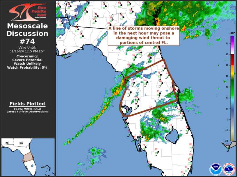
   Mesoscale Discussion 0074
   NWS Storm Prediction Center Norman OK
   1017 AM CST Tue Jan 16 2024

   Areas affected...Central Florida

   Concerning...Severe potential...Watch unlikely

   Valid 161617Z - 161815Z

   Probability of Watch Issuance...5 percent

   SUMMARY...A line of storms moving onto the Florida west coast within
   the next hour may pose a risk of damaging winds. Watch issuance is
   not anticipated.

   DISCUSSION...A band of convection focused along a cold front is
   slowly approaching the FL west coast per recent radar/satellite
   imagery. GOES IR and lightning trends show a few intensifying
   updrafts within the line, denoted by concentrated lightning clusters
   and cooling cloud top temperatures. This trend should continue as
   the line moves onshore where temperatures are warming into the
   low/mid 70s and MLCAPE values are slowly increasing to 1000-1500
   J/kg. VWP observations from KTBW show 0-6 km BWD values around 50-60
   knots, but deep-layer shear vectors are largely oriented along the
   boundary with weak line-normal deep-layer shear. This may limit the
   overall organization/intensity of the line, but may support stronger
   embedded segments capable of damaging winds. This kinematic regime
   is not overly favorable for line-embedded tornadoes, but a brief
   tornado appears possible if a portion of the line can become more
   oriented from southeast to northwest. Confidence in this scenario is
   low at this time given recent storm trends, and a damaging wind risk
   appears more probable. Regardless, the overall severe threat appears
   too limited to warrant watch issuance.

   ..Moore/Thompson.. 01/16/2024

   ...Please see www.spc.noaa.gov for graphic product...

   ATTN...WFO...MLB...TBW...JAX...

   LAT...LON   28268276 28578263 28918271 29598115 29228100 28878081
               28458073 28238066 28158070 27668245 27638262 27658273
               27868287 28028286 28268276
|
|
Top/All Mesoscale Discussions/Forecast Products/Home
|
|


 @NWSSPC