|
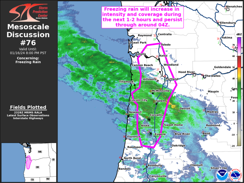
| Mesoscale Discussion 76 |
|
< Previous MD Next MD >
|

|
   Mesoscale Discussion 0076
   NWS Storm Prediction Center Norman OK
   0531 PM CST Tue Jan 16 2024

   Areas affected...Portions of northwest OR into far southwest WA

   Concerning...Freezing rain

   Valid 162331Z - 170400Z

   SUMMARY...Freezing rain will increase in both intensity and coverage
   across much of the Willamette Valley, the Oregon Coast Range, and
   the far southern Chehalis River Valley during the next 1-2 hours and
   persist through around 04Z.

   DISCUSSION...Latest water vapor imagery depicts a compact midlevel
   cyclone tracking eastward toward the Pacific Northwest. Strong DCVA
   preceding the cyclone should overspread coastal OR over the next 1-2
   hours, supporting an increase in precipitation intensity and
   coverage across the region. The 12Z SLE observed sounding and more
   recent Portland ACARS soundings showed lingering dry air in the
   1-5-km layer, though persistent precipitation (and related
   wet-bulbing) along with increasing moisture ahead of the
   aforementioned cyclone are likely contributing to a deep saturated
   layer which will further support increasing precipitation rates. In
   fact, freezing rain is beginning to increase in coverage across
   coastal OR per the latest surface observations.

   Low to mid 20s surface wet bulb temperatures beneath a 3-4 deg C
   warm nose as low as 925 mb in the Willamette Valley into the Oregon
   Coast Range will support complete hydrometeor melting and
   re-freezing at the surface, suggesting that freezing rain will be
   the predominant precipitation type (with pockets of sleet also
   possible). And, given the strengthening large-scale ascent amid a
   deeply saturated thermodynamic profile, freezing rain rates could
   exceed 0.1 inch/hour. These conditions will likely persist through
   around 04Z, before surface temperatures begin to warm and the dry
   conveyor belt accompanying the midlevel cyclone impinges on the
   area.

   ..Weinman.. 01/16/2024

   ...Please see www.spc.noaa.gov for graphic product...

   ATTN...WFO...MFR...SEW...PQR...

   LAT...LON   44262371 44892370 44992384 45192392 45342363 45682358
               46122370 46472335 46522282 45892250 45412222 45042253
               44372277 44022285 43742309 43792355 44262371
|
|
Top/All Mesoscale Discussions/Forecast Products/Home
|
|


