Mesoscale Discussion 0091
NWS Storm Prediction Center Norman OK
1022 AM CST Thu Jan 25 2024
Areas affected...parts of southeast and east central Mississippi
into southwest and west central Alabama
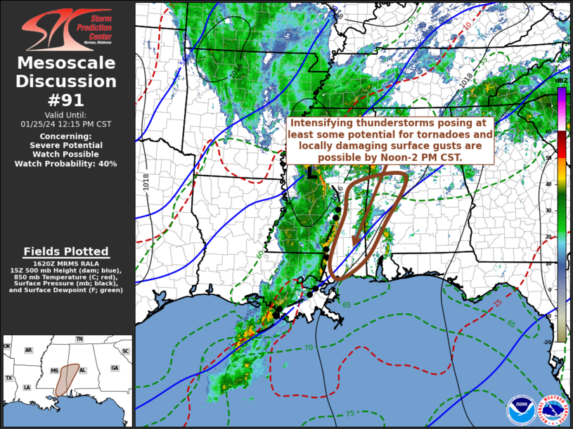
Concerning...Severe potential...Watch possible
Valid 251622Z - 251815Z
Probability of Watch Issuance...40 percent
SUMMARY...Intensifying thunderstorm development through Noon-2 PM
CST may begin to pose at least some risk for tornadoes and locally
damaging wind gusts. While the need for a severe weather watch is
still not certain, trends will continue to be monitored for this
possibility.
DISCUSSION...Thunderstorms, along the leading edge of weak
convective outflow advancing eastward and northeastward toward the
Hattiesburg and Meridian vicinities, have tended to weaken the past
couple of hours. However, new discrete thunderstorm development has
being occurring in advance of the outflow, and may be in the process
of intensifying, along the eastern flank of a strengthening
southerly low-level jet (including 40-50 kt around 850 mb).
This coincides with a corridor of low-level moistening and
destabilization, across southeastern Mississippi through the central
Mississippi/Alabama border vicinity, where further erosion of a
remnant shallow surface-based stable layer may allow for more
substantive thunderstorm intensification by early afternoon. In the
presence of strong deep-layer shear, sizable clockwise curved
low-level hodographs in advance of the convective outflow may become
conducive to supercells with potential to produce tornadoes. Closer
to the approaching outflow boundary, low-level hodographs are
generally forecast to become more linear, but strengthening
convection could become conducive to increasing risk for potentially
damaging wind gusts.
..Kerr/Guyer.. 01/25/2024
...Please see www.spc.noaa.gov for graphic product...
ATTN...WFO...BMX...MOB...JAN...LIX...
LAT...LON 32068910 32918884 33148712 31768784 30838843 30288925
30618956 31218944 32068910
|


 @NWSSPC