|
| Mesoscale Discussion 128 |
|
< Previous MD Next MD >
|
|
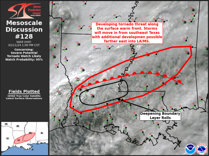
   Mesoscale Discussion 0128
   NWS Storm Prediction Center Norman OK
   1104 AM CST Sun Feb 11 2024

   Areas affected...Parts of central/southern Louisiana into southern
   Mississippi

   Concerning...Severe potential...Tornado Watch likely

   Valid 111704Z - 111900Z

   Probability of Watch Issuance...95 percent

   SUMMARY...A threat for tornadoes, possibly strong, and very large
   hail will develop this afternoon along the warm front in central LA
   into southern MS. A tornado watch is likely for parts of these
   areas.

   DISCUSSION...Upper 60s F dewpoints are present south of the slowly
   lifting warm front across central LA/southern MS. A cirrus plume
   associated with the subtropical jet has generally shifted east
   allowing at least broken surface heating into the low 70s F. With
   time, additional heating should promote 1000-1500 J/kg MLCAPE by the
   afternoon. Deep-layer shear is more than adequate for supercells,
   which are already ongoing in southeast Texas moving roughly parallel
   to the warm front. Supercell storms that can remain near the
   boundary will take advantage of enhanced low-level shear/SRH. There
   are signs of modestly deepening boundary-layer rolls in the vicinity
   of central LA/southwest MS. This is a potential area for additional
   storm development later today, which has also been hinted at by
   recent HRRR runs. Mid-level ascent is currently weak so it may take
   more time for any potential development to occur. Given the
   environment, tornadoes, some potentially strong, and very large hail
   (1.75-2.75 in.) are possible. A tornado watch will likely be needed
   within the next 2 hours, unless storms develop along the warm front
   sooner than anticipated.

   ..Wendt/Thompson.. 02/11/2024

   ...Please see www.spc.noaa.gov for graphic product...

   ATTN...WFO...JAN...LIX...LCH...SHV...

   LAT...LON   31079341 31129336 31499279 32089135 32568941 32578863
               32258861 31588922 31168991 30859061 30649154 30409246
               30239321 30439360 30809354 31079341
|
|
Top/All Mesoscale Discussions/Forecast Products/Home
|
|


 @NWSSPC