|
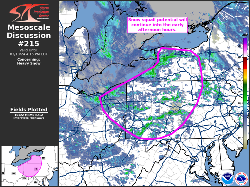
| Mesoscale Discussion 215 |
|
< Previous MD Next MD >
|

|
   Mesoscale Discussion 0215
   NWS Storm Prediction Center Norman OK
   1113 AM CDT Sun Mar 10 2024

   Areas affected...Northeast Ohio into western/central Pennsylvania
   and western New York

   Concerning...Heavy snow

   Valid 101613Z - 102015Z

   SUMMARY...Snow squall potential will persist into the early
   afternoon hours across northeast Ohio into western/central
   Pennsylvania, and western New York.

   DISCUSSION...Over the past few hours, a combination of broken cloud
   cover and low/mid-level cold air advection over the upper OH river
   valley and lower Great Lakes region has allowed for low-level lapse
   rates to steepen to 7-8 C/km. These steep lapse rates are supporting
   shallow convection across central to western PA with a history of
   producing snow squall conditions (reduced visibility to 0.25 mile at
   times with moderate snowfall rates and wind gusts upwards of 25-30
   mph). The expectation is for this thermodynamic regime to largely
   remain in place through at least early afternoon before cold air
   advection in the 925-850 mb layer wanes later in the day. As
   low/mid-level destabilization continues for the next few hours,
   SBCAPE values should approach 250 J/kg, resulting in an
   intensification of precipitation/snowfall rates within convective
   snow showers. Recent high-res guidance suggests additional snow
   bands will propagate off of Lake Erie through early afternoon into
   northeast OH, PA, and western NY. One such band is evident in
   regional reflectivity across far western NY, lending confidence in
   this overall scenario. Consequently, the potential for snow squalls
   should continue for the next several hours.

   ..Moore.. 03/10/2024

   ...Please see www.spc.noaa.gov for graphic product...

   ATTN...WFO...BGM...BUF...CTP...PBZ...CLE...

   LAT...LON   41328191 41648123 42557910 42757886 43057888 43307869
               43187713 42927671 42457659 41767653 41117684 40297758
               39927815 39757875 39727937 39747984 40028047 40508133
               40828171 41328191
|
|
Top/All Mesoscale Discussions/Forecast Products/Home
|
|


