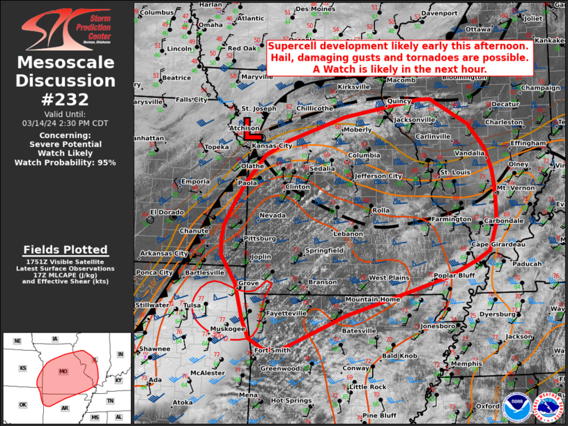
   Mesoscale Discussion 0232
   NWS Storm Prediction Center Norman OK
   1258 PM CDT Thu Mar 14 2024

   Areas affected...parts of far southeast KS...northwest AR...MO and
   western IL

   Concerning...Severe potential...Watch likely

   Valid 141758Z - 141930Z

   Probability of Watch Issuance...95 percent

   SUMMARY...Storm development appears likely early this afternoon
   across a broad warm sector with multiple boundaries. Supercells
   capable of all hazards appear likely given sufficient shear and
   buoyancy. A WW is likely in the next hour.

   DISCUSSION...Early afternoon visible imagery showed a broad cumulus
   field becoming progressively more agitated east of a slow-moving
   cold front across parts of far southeastern KS, northwest AR and
   southwestern MO. Multiple modifying outflow/differential heating
   boundaries lie across the warm sector and near the front as observed
   by area ME TARS. Strong diurnal heating is ongoing and expected to
   continue modifying the air mass across the warm sector and along
   these boundaries. With the ongoing heating, surface dewpoints in the
   low to mid 60s F are supporting 1500-2500 J/kg of MLCAPE with
   minimal CINH remaining. Area model soundings and VAD wind profiles
   indicate moderate to strong effective shear of 45-55 kt supportive
   of storm organization. While low-level flow is somewhat veered,
   supercell wind profiles are in place and subtle forcing for ascent
   will favor a more cellular mode, at least initially. Steep lapse
   rates, moderate buoyancy and favorable shear will support a risk for
   all hazards, especially significant hail, with storms able to
   develop.

   Hi-res CAM and experimental WOFS guidance solutions show storm
   development along the front, across the outflow/differential heating
   axis, and within the warm-sector across northwestern AR are all
   possible early this afternoon. While an initially discrete storm
   mode is expected, additional development southwest, and numerous
   storm interactions appear likely. Upscale growth into multiple
   clusters with supercell and short bowing segment structures will
   support multiple severe hazards. Given the increasing severe risk a
   new Tornado Watch is likely within the next hour.

   ..Lyons/Goss.. 03/14/2024

   ...Please see www.spc.noaa.gov for graphic product...

   ATTN...WFO...PAH...ILX...LSX...LZK...SGF...EAX...TSA...ICT...

   LAT...LON   36599075 36129233 35489380 35509419 35699451 36029466
               36679484 37199517 37509517 37749512 38049496 38519464
               39019421 39289368 39739236 40039066 40049037 39598950
               39148912 38748897 38388890 37788888 37278906 37118935
               36828999 36599075
|


 @NWSSPC