|
| Mesoscale Discussion 248 |
|
< Previous MD Next MD >
|
|
Mesoscale Discussion 0248
NWS Storm Prediction Center Norman OK
0831 PM CDT Thu Mar 14 2024
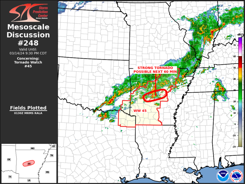
Areas affected...Central Arkansas
Concerning...Tornado Watch 45...
Valid 150131Z - 150230Z
The severe weather threat for Tornado Watch 45 continues.
SUMMARY...A strong tornado will be possible in the vicinity of
western Little Rock over the next hour.
DISCUSSION...Low-level flow as increased over the last hour across
central Arkansas. 0-1 km storm-relative helicity on the WSR-88D VWP
at Little Rock has increased from near 150 m2/s2 to about 225 m2/s2.
This increase in low-level shear will continue to support a tornado
threat. The storm to the west of Little Rock in the area around Hot
Springs has had a history of tornadoes. As this storm moves
east-northeastward, the storm-scale environment could support the
development of a strong tornado in the vicinity of western Little
Rock over the next 60 minutes.
..Broyles.. 03/15/2024
...Please see www.spc.noaa.gov for graphic product...
ATTN...WFO...LZK...
LAT...LON 34799183 34639228 34489325 34839342 35139256 35199193
35009172 34799183
|
|
Top/All Mesoscale Discussions/Forecast Products/Home
|
|


 @NWSSPC