|
| Mesoscale Discussion 256 |
|
< Previous MD Next MD >
|
|
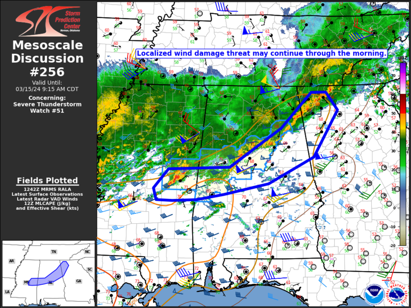
   Mesoscale Discussion 0256
   NWS Storm Prediction Center Norman OK
   0745 AM CDT Fri Mar 15 2024

   Areas affected...East-central MS into central/northeast AL and
   northwest GA

   Concerning...Severe Thunderstorm Watch 51...

   Valid 151245Z - 151415Z

   The severe weather threat for Severe Thunderstorm Watch 51
   continues.

   SUMMARY...A localized damaging-wind threat may persist through the
   morning.

   DISCUSSION...A long-lived QLCS is gradually moving eastward across
   parts of MS/AL into northwest GA this morning. Within the larger
   QLCS, shorter line segments have occasionally taken on a north-south
   orientation through the early morning, accompanied by some increase
   in organization and damaging-wind potential. This general trend may
   persist into mid morning, with an isolated damaging-wind threat
   accompanying the stronger line segments that do not get undercut by
   outflow.

   Some threat may spread outside of WW 51 into northwest GA, though
   the need for downstream watch issuance is uncertain, due to weaker
   instability with northeastward extent (as noted in the 12Z FFC
   sounding and objective mesoanalyses). Farther southwest, some uptick
   remains possible from east-central MS into central AL, where MLCAPE
   of 500-1000 J/kg and favorable deep-layer shear remain in place this
   morning. Local watch extension may need to be considered for parts
   of MS/AL, depending on short-term convective trends.

   ..Dean/Thompson.. 03/15/2024

   ...Please see www.spc.noaa.gov for graphic product...

   ATTN...WFO...FFC...BMX...HUN...JAN...

   LAT...LON   33048915 33118746 34018604 34848520 34838479 34428447
               33348515 32728639 32478762 32358836 32318902 32338946
               32608954 33048915
|
|
Top/All Mesoscale Discussions/Forecast Products/Home
|
|


 @NWSSPC