|
| Mesoscale Discussion 280 |
|
< Previous MD Next MD >
|

|
   Mesoscale Discussion 0280
   NWS Storm Prediction Center Norman OK
   0509 AM CDT Fri Mar 22 2024

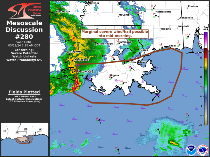
   Areas affected...Coastal southeast LA

   Concerning...Severe potential...Watch unlikely

   Valid 221009Z - 221215Z

   Probability of Watch Issuance...5 percent

   SUMMARY...An organized but elevated QLCS should continue eastward
   across the rest of southeast LA through mid-morning. The tail end of
   the line segment along the immediate coast will have the best chance
   to produce strong gusts from 45-60 mph and marginally severe hail of
   0.75-1.25".

   DISCUSSION...A longer-lived MCS with a history of embedded bowing
   structures has largely evolved into more of a north/south-oriented
   short-line segment across south-central LA and the adjacent
   nearshore waters. A pronounced rear-inflow jet is evident in the
   time-series of LCH VWP data, and this line segment should remain
   organized as it progresses east across southeast LA. Peak measured
   wind gusts have ranged from 45-50 mph, as the elevated character of
   the line segment has mitigated severe gusts at the surface. With the
   line paralleling the MUCAPE gradient, convection closer to the
   immediate coast will have the best chance to become marginally
   severe. The offshore surface warm front should continue to drift
   north, but it does not appear it will advance inland fast enough
   relative to the line's forward speed, outside of possibly
   Plaquemines Parish.

   ..Grams/Edwards.. 03/22/2024

   ...Please see www.spc.noaa.gov for graphic product...

   ATTN...WFO...LIX...LCH...

   LAT...LON   29929171 29969092 30078997 30298929 30378875 30248844
               29798849 29078880 28908918 28838954 28869006 28889124
               29159181 29929171
|
|
Top/All Mesoscale Discussions/Forecast Products/Home
|
|


