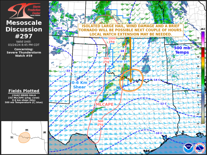
   Mesoscale Discussion 0297
   NWS Storm Prediction Center Norman OK
   0646 PM CDT Sun Mar 24 2024

   Areas affected...Southern Oklahoma...North Texas

   Concerning...Severe Thunderstorm Watch 59...

   Valid 242346Z - 250145Z

   The severe weather threat for Severe Thunderstorm Watch 59
   continues.

   SUMMARY...Isolated large hail, damaging wind gusts and potential for
   a brief tornado will likely continue for a couple more hours. As
   this storms moves to the east of WW 59, a local extension in area
   may be needed across parts of the area.

   DISCUSSION...The latest surface analysis shows a trough extending
   southward across west Texas, with a dryline to the east of the
   trough. Scattered thunderstorms are ongoing to the east of the
   dryline in northwest Texas, where surface dewpoints are in the mid
   to upper 50s F and MLCAPE is estimated in the 500 to 1000 J/kg
   range. The Frederick WSR-88D VWP currently has 0-6 km shear near 60
   knots, and veering winds with height in the lowest 1 km. This, along
   with strong large-scale ascent associated with an approaching
   shortwave trough, will support a threat for supercells and large
   hail. Wind damage will also be possible. In addition, low-level
   shear appears sufficient for a tornado threat, but any threat should
   remain isolated and brief. As the storm in eastern Wichita County
   near the Red River moves further east into the weaker instability, a
   downtrend is eventually expected to occur.

   ..Broyles/Guyer.. 03/24/2024

   ...Please see www.spc.noaa.gov for graphic product...

   ATTN...WFO...FWD...OUN...

   LAT...LON   34699742 34629787 34389836 33959866 33519865 33189838
               33089792 33119749 33249715 33469683 33829667 34179665
               34569692 34699742
|


 @NWSSPC