|
| Mesoscale Discussion 345 |
|
< Previous MD Next MD >
|

|
   Mesoscale Discussion 0345
   NWS Storm Prediction Center Norman OK
   1058 AM CDT Tue Apr 02 2024

   Areas affected...Portions of far eastern IL...extreme northern
   KY...and southern/central IN

   Concerning...Severe potential...Watch possible

   Valid 021558Z - 021830Z

   Probability of Watch Issuance...40 percent

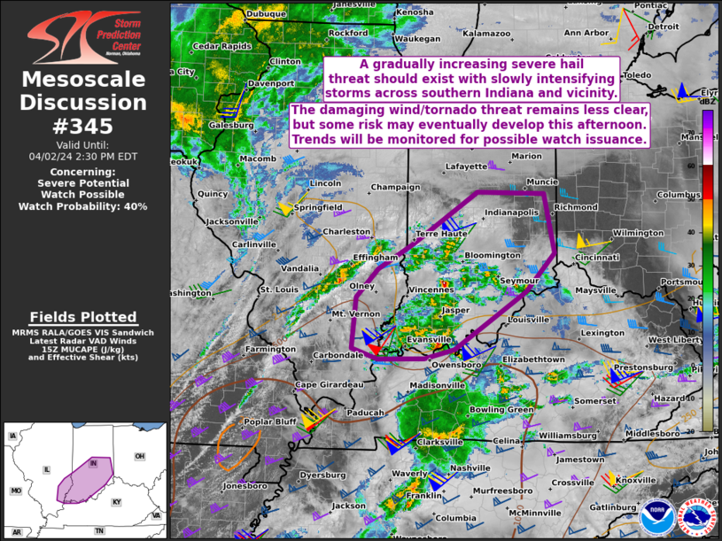
   SUMMARY...A gradually increasing severe hail threat should exist
   with slowly intensifying thunderstorms across southern Indiana and
   vicinity. The damaging wind and tornado threat remain less clear,
   but some risk may eventually develop this afternoon. Trends will be
   monitored for possible watch issuance.

   DISCUSSION...Convection has been gradually increasing in coverage
   over the past hour or so across southern IN and vicinity. This
   activity is largely tied to pronounced ascent associated with a very
   strong southwesterly mid/upper-level jet. Most of these
   thunderstorms are currently elevated, and located to the north of an
   outflow boundary related to earlier morning convection now in WV.
   Still, visible satellite and surface observation trends show
   attempts at low-level moisture returning northward ahead of these
   thunderstorms and filtered daytime heating across parts of
   southern/central IN. While MUCAPE remains weak at the moment,
   instability and deep-layer shear are both forecast to increase
   through the afternoon as a northern and southern-stream shortwave
   trough phase over the Midwest. This should support a threat for
   supercells capable of producing mainly severe hail initially. The
   risk for damaging winds and tornadoes this afternoon will be
   dependent on whether sufficient low-level moistening/warming will
   occur to support truly surface-based convection. Regardless of this
   continued uncertainty with instability, the gradually increasing
   severe threat over the next few hours may eventually prompt watch
   issuance.

   ..Gleason/Thompson.. 04/02/2024

   ...Please see www.spc.noaa.gov for graphic product...

   ATTN...WFO...ILN...LMK...IND...PAH...ILX...

   LAT...LON   37778803 37938850 38648844 39058804 39398743 40148624
               40118503 39268486 38738537 37928666 37798721 37778803
|
|
Top/All Mesoscale Discussions/Forecast Products/Home
|
|


