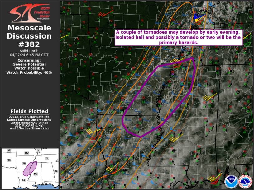
   Mesoscale Discussion 0382
   NWS Storm Prediction Center Norman OK
   0520 PM CDT Sun Apr 07 2024

   Areas affected...Southeast AR...Northeast LA...Southwest
   TN...Northwest MS

   Concerning...Severe potential...Watch possible

   Valid 072220Z - 072345Z

   Probability of Watch Issuance...40 percent

   SUMMARY...A couple of supercells may develop by early evening, with
   a threat of isolated hail and possibly a tornado or two.

   DISCUSSION...Cumulus has been gradually increasing late this
   afternoon from eastern AR into northern LA, in advance of a nearly
   stationary surface front, with recent attempts at initiation noted.
   Diurnal heating of a relatively moist airmass has resulted in MLCAPE
   increasing to 1000-1500 J/kg. With generally neutral large-scale
   ascent and only weak convergence near the surface boundary, storm
   coverage may remain rather isolated, but with favorable deep-layer
   shear in place, a couple of supercells could eventually evolve as
   storms slowly mature into early evening.

   With time, storms will tend to move northeastward out of the
   low-level moist axis, so the longevity of any severe threat is
   uncertain. However, some threat of isolated hail and locally gusty
   winds would accompany any supercells. Modestly favorable low-level
   shear/SRH (as noted from the KNQA VWP) could also support some
   tornado potential, if robust supercells can be sustained. While the
   threat may remain somewhat marginal, watch issuance is possible due
   to supercell potential.

   ..Dean/Hart.. 04/07/2024

   ...Please see www.spc.noaa.gov for graphic product...

   ATTN...WFO...MEG...JAN...LZK...SHV...

   LAT...LON   33948963 32669094 32149196 32249227 32369260 32669281
               32899283 33249262 34659150 34989115 35188994 35208991
               35318947 34918936 34258952 33948963
|


 @NWSSPC