|
| Mesoscale Discussion 388 |
|
< Previous MD Next MD >
|
|
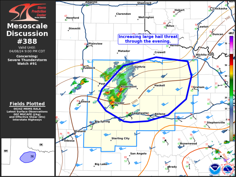
   Mesoscale Discussion 0388
   NWS Storm Prediction Center Norman OK
   0727 PM CDT Mon Apr 08 2024

   Areas affected...portions of northwest Texas

   Concerning...Severe Thunderstorm Watch 91...

   Valid 090027Z - 090200Z

   The severe weather threat for Severe Thunderstorm Watch 91
   continues.

   SUMMARY...The threat for large hail will increase through the
   evening.

   DISCUSSION...Storms have formed and moved north of a frontal zone
   across Northwest Texas. The long, straight hodograph, evident on the
   LBB VWP) supports splitting supercells, with a few already evident
   in that region. In fact, the only hail report thus far (1.75") came
   from a left-moving supercell. Expect this cluster of supercells to
   continue northeast and gradually intensify through the evening as
   instability increases with northwestward moisture advection. Limited
   instability to the north of this cluster should limit the longevity
   of left-movers, with the hail threat remaining mostly south of the
   Red River.

   Watch 91 will be cleared in the wake of this cluster of supercells.
   An additional threat for large hail is expected overnight as
   stronger ascent overspreads the southern Plains, but this will be
   handled with a separate watch, if necessary.

   ..Bentley/Hart.. 04/09/2024

   ...Please see www.spc.noaa.gov for graphic product...

   ATTN...WFO...FWD...OUN...SJT...LUB...MAF...

   LAT...LON   32570114 32820137 33100126 33530082 33690062 33780023
               33909965 33809872 33439860 32869877 32479930 32319991
               32290041 32310060 32570114
|
|
Top/All Mesoscale Discussions/Forecast Products/Home
|
|


 @NWSSPC