|
| Mesoscale Discussion 396 |
|
< Previous MD Next MD >
|
|
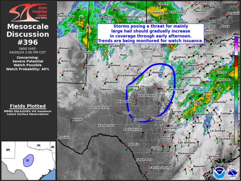
   Mesoscale Discussion 0396
   NWS Storm Prediction Center Norman OK
   1130 AM CDT Tue Apr 09 2024

   Areas affected...Portions of northwest into central TX

   Concerning...Severe potential...Watch possible

   Valid 091630Z - 091900Z

   Probability of Watch Issuance...40 percent

   SUMMARY...Thunderstorms posing a threat for mainly large hail should
   gradually increase in coverage through early afternoon. Trends are
   being monitored for possible watch issuance.

   DISCUSSION...16Z surface observations show a front draped across
   west into north-central TX, with a dryline extending south from the
   front towards the Big Bend vicinity. Occasional supercells have been
   occurring this morning to the north of the front across western
   north TX, with mainly a large hail threat but occasional measured
   severe wind gusts too. Recent radar and visible satellite trends
   indicate another thunderstorm has developed north of San Angelo near
   the front/dryline intersection. The airmass downstream appears
   favorable for supercells, with moderate instability and strong
   deep-layer shear likely to support updraft organization. As ascent
   associated with the upper low over the Southwest and attendant
   mid-level jet nosing into the southern High Plains continues to
   overspread the warm sector, most high-resolution guidance shows
   additional supercells developing through early afternoon. Given the
   presence of steep mid-level lapse rates and elongated/nearly
   straight hodographs at mid/upper levels, scattered large to very
   large hail (1.5-2.5 inches in diameter) should be the main severe
   threat. Isolated strong to locally severe winds may also occur with
   any convective downdrafts. Trends will be monitored through the rest
   of the morning and into early afternoon for signs of additional
   robust thunderstorm development, which may prompt eventual watch
   issuance.

   ..Gleason/Thompson.. 04/09/2024

   ...Please see www.spc.noaa.gov for graphic product...

   ATTN...WFO...FWD...SJT...MAF...

   LAT...LON   31800099 32100070 32490019 32839970 32889909 32639864
               31919857 31279877 30739924 30420006 30680080 31800099
|
|
Top/All Mesoscale Discussions/Forecast Products/Home
|
|


 @NWSSPC