|
| Mesoscale Discussion 402 |
|
< Previous MD Next MD >
|
|
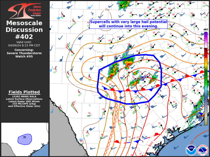
   Mesoscale Discussion 0402
   NWS Storm Prediction Center Norman OK
   0640 PM CDT Tue Apr 09 2024

   Areas affected...Portions of central TX

   Concerning...Severe Thunderstorm Watch 95...

   Valid 092340Z - 100115Z

   The severe weather threat for Severe Thunderstorm Watch 95
   continues.

   SUMMARY...Supercells with very large hail potential will continue
   this evening.

   DISCUSSION...Several discrete supercells are ongoing early this
   evening across central TX, with recent reports of 2+ inch hail
   across the north side of Austin. These cells are ongoing north of a
   nearly stationary surface boundary, where MLCAPE of 1500-2500 J/kg
   and effective shear of 50+ kt will continue to provide a favorable
   supercell environment through much of the evening, with a threat of
   very large hail (potentially in the 1.75 - 2.5 inch diameter range)
   and localized severe gusts. A brief tornado also cannot be ruled out
   with any sustained supercell near the surface boundary.

   While storms should generally move eastward north of the boundary
   through early evening, more isolated development will be possible
   near the intersection of the front and a weak surface
   trough/effective dryline extending into portions of south-central
   TX, where stronger heating/mixing occurred this afternoon. Later
   this evening, the western portion of the front may begin
   accelerating southward with increasing storm coverage, though timing
   of any such development remains uncertain.

   ..Dean.. 04/09/2024

   ...Please see www.spc.noaa.gov for graphic product...

   ATTN...WFO...HGX...FWD...EWX...SJT...

   LAT...LON   30809943 31099880 31349794 31369754 31339719 31079695
               30809687 30219689 29909716 29699742 29659766 29619800
               29619832 29799912 29899932 30039947 30209949 30809943
|
|
Top/All Mesoscale Discussions/Forecast Products/Home
|
|


 @NWSSPC