|
| Mesoscale Discussion 691 |
|
< Previous MD Next MD >
|
|
Mesoscale Discussion 0691
NWS Storm Prediction Center Norman OK
0323 AM CDT Wed May 08 2024
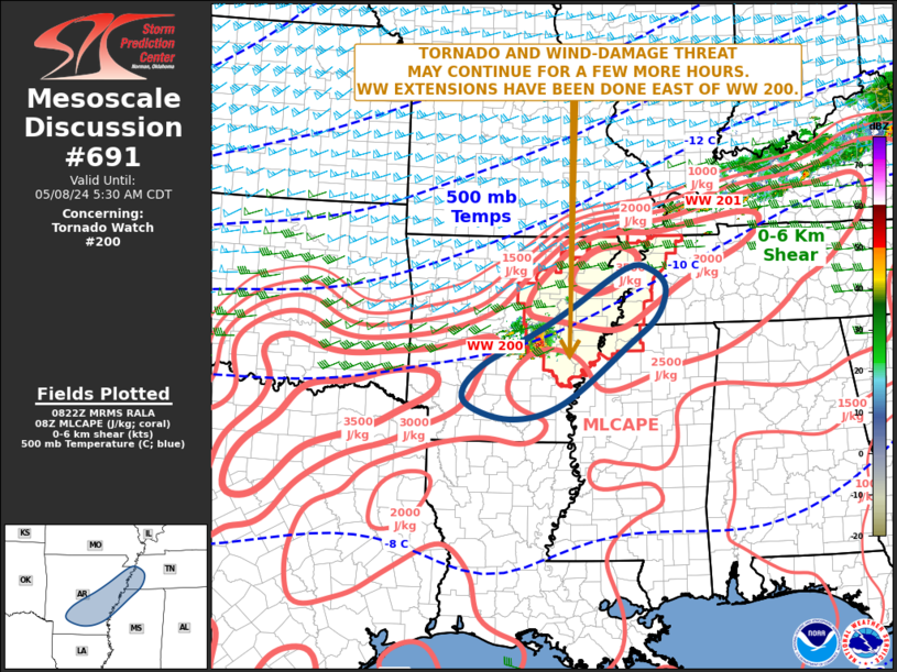
Areas affected...Arkansas...Far Northwest Mississippi...Far
Southwest Tennessee
Concerning...Tornado Watch 200...
Valid 080823Z - 081030Z
The severe weather threat for Tornado Watch 200 continues.
SUMMARY...A tornado and wind-damage threat may continue for a few
more hours across WW 200. The threat may affect parts of far
northwest Mississippi and far southwest Tennessee later this
morning. A watch extension has been done to account for this
possibility.
DISCUSSION...The latest hi-resolution radar imagery from Little
Rock, AR shows a cluster of strong thunderstorms located about 30
statute miles to the east of Little Rock. A supercell is embedded
toward the eastern edge of the cluster. The RAP is analyzing
moderate instability across eastern Arkansas, with MLCAPE generally
ranging from 2000 to 2500 J/kg. This will help to maintain
convective development as the cluster moves eastward over the next
few hours. In addition, the Little Rock WSR-88D VWP has 0-6 km shear
near 45 knots, with 0-1 km storm-relative helicity just above 100
m2/s2. This should continue to support an isolated tornado threat
with supercells. A wind-damage threat may also accompany any cells
that remain organized.
..Broyles.. 05/08/2024
...Please see www.spc.noaa.gov for graphic product...
ATTN...WFO...MEG...JAN...LZK...SHV...
LAT...LON 34889181 34239304 33699333 33389241 33649130 34658993
35138935 35628917 35938947 35968998 35259116 34889181
|
|
Top/All Mesoscale Discussions/Forecast Products/Home
|
|


 @NWSSPC