|
| Mesoscale Discussion 693 |
|
< Previous MD Next MD >
|
|
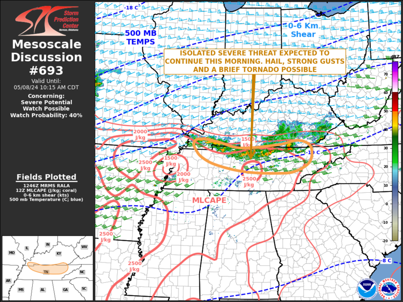
   Mesoscale Discussion 0693
   NWS Storm Prediction Center Norman OK
   0750 AM CDT Wed May 08 2024

   Areas affected...Southern Kentucky...Tennessee

   Concerning...Severe potential...Watch possible

   Valid 081250Z - 081515Z

   Probability of Watch Issuance...40 percent

   SUMMARY...An isolated severe threat is expected to continue this
   morning. The stronger storms will have potential for hail, strong
   gusts and a brief tornado. Weather watch issuance may become
   necessary later this morning.

   DISCUSSION...The latest mosaic radar imagery in the Tennessee Valley
   shows numerous thunderstorms along an east-to-west outflow boundary,
   from southern Kentucky into northern Tennessee. To the south of this
   convection, the RAP has moderate instability in place, with MLCAPE
   generally in the 2000 to 2500 J/kg range. Forecast soundings in
   northern Tennessee this morning suggest the activity is
   surface-based. WSR-88D VWPs along and near the outflow boundary have
   0-6 km shear in the 45 to 50 knot range, which will continue to be
   sufficient for supercells and bowing line segments. Wind damage and
   hail the primary threats. However, VWPs also have 0-1 km shear in
   the 20 to 25 knot range near this feature, suggesting that a brief
   tornado will be possible with embedded supercells.

   ..Broyles/Edwards.. 05/08/2024

   ...Please see www.spc.noaa.gov for graphic product...

   ATTN...WFO...MRX...JKL...LMK...OHX...PAH...MEG...

   LAT...LON   35698430 35638514 35668620 35788711 35988802 36248855
               36468876 36718889 36898867 36818785 36588672 36708500
               36848408 36608352 36038359 35698430
|
|
Top/All Mesoscale Discussions/Forecast Products/Home
|
|


 @NWSSPC