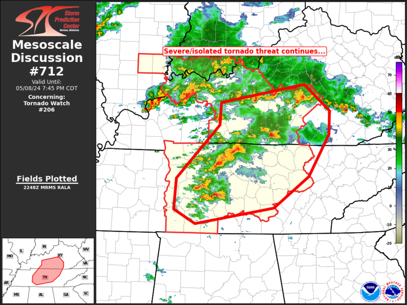
   Mesoscale Discussion 0712
   NWS Storm Prediction Center Norman OK
   0551 PM CDT Wed May 08 2024

   Areas affected...Middle Tennessee...south-central Kentucky

   Concerning...Tornado Watch 206...

   Valid 082251Z - 090045Z

   The severe weather threat for Tornado Watch 206 continues.

   SUMMARY...Several supercells are ongoing across parts of the
   Mid-South region (south-central Kentucky and Middle Tennessee).
   Storms will continue over the next couple of hours, with large hail
   and damaging winds expected, along with a few tornadoes.

   DISCUSSION...Scattered severe/supercell storms continue across
   portions of the southern half of Kentucky at this time, and
   southward into Middle Tennessee.  Several of these storms are
   exhibiting sustained rotation, and large hail signatures as they
   move eastward across WW 206.  One storm in particular, moving across
   Maury County at this time, appears to be potentially tornadic, per
   KOHX WSR-88D storm-relative velocity (roughly 65 kt VROT) and
   correlation coefficient data from the most recent volume scan.

   Instability diminishes with eastward extent into eastern portions of
   Kentucky, but expect some severe risk to spill east of the existing
   WW.  Farther south, into eastern Tennessee, greater instability
   suggests greater risk for eventual eastward expansion of severe
   potential.  At this time, expectations are that risk into eastern
   Kentucky may remain sufficiently muted to preclude a downstream WW
   in the short term.  Later, with WW 206 set to expire at 09/03Z, a
   new WW may be needed, and could include eastern Tennessee counties
   east of the current watch, and potentially a few counties into
   southern portions of eastern Kentucky.

   ..Goss.. 05/08/2024

   ...Please see www.spc.noaa.gov for graphic product...

   ATTN...WFO...MRX...JKL...LMK...OHX...HUN...PAH...

   LAT...LON   35178734 35438782 35998777 36978679 37388677 37718487
               37228430 36798431 36028478 35458557 35178734
|


 @NWSSPC