|
| Mesoscale Discussion 734 |
|
< Previous MD Next MD >
|

|
   Mesoscale Discussion 0734
   NWS Storm Prediction Center Norman OK
   0439 PM CDT Thu May 09 2024

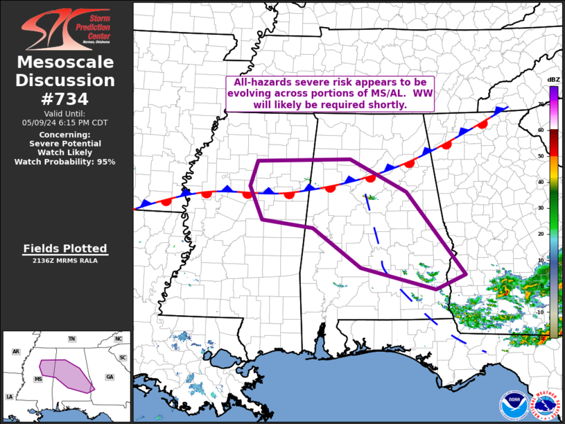
   Areas affected...northeastern Mississippi into a large portion of
   Alabama

   Concerning...Severe potential...Watch likely

   Valid 092139Z - 092315Z

   Probability of Watch Issuance...95 percent

   SUMMARY...Convective initiation is ongoing across northern Alabama,
   and will likely expand over the next 1 to 2 hours.  New WW will
   likely be needed.

   DISCUSSION...Latest visible satellite imagery shows a developing
   convective tower near Birmingham, near the intersection of a weak
   west-to-east baroclinic zone, and an outflow boundary from prior
   convection that extends southward/south-southeastward into
   southeastern Alabama.  While large-scale ascent appears to be weak,
   an otherwise volatile environment is in place, with mixed-layer CAPE
   averaging 3000 to 4000 J/kg on the warm side of these boundaries,
   and strong mid-level westerly flow (in excess of 60 kt at mid
   levels).  Should additional convection evolve -- as appears likely
   per the character of the cu field -- substantial severe-weather risk
   would accompany the storms.  This would include potential for
   strong/damaging winds and very large hail.  Some tornado risk could
   also evolve locally, given the presence of the aforementioned
   boundaries, though low-level flow/shear appears limited at this
   time.

   ..Goss/Hart.. 05/09/2024

   ...Please see www.spc.noaa.gov for graphic product...

   ATTN...WFO...FFC...TAE...BMX...HUN...MOB...MEG...JAN...

   LAT...LON   33578965 34068948 34108732 33468603 31848469 31578538
               32008709 32768819 32928935 33578965
|
|
Top/All Mesoscale Discussions/Forecast Products/Home
|
|


