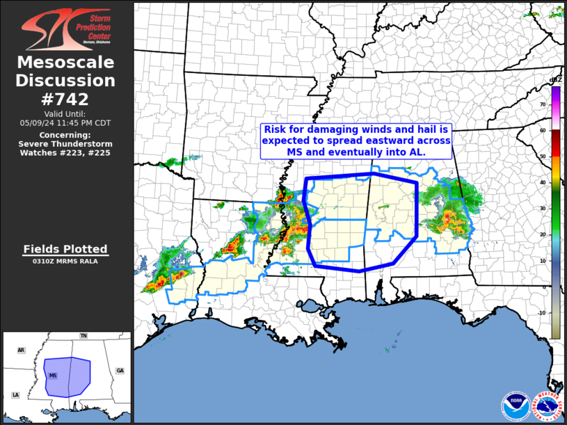
   Mesoscale Discussion 0742
   NWS Storm Prediction Center Norman OK
   1012 PM CDT Thu May 09 2024

   Areas affected...central and eastern Mississippi into western
   Alabama

   Concerning...Severe Thunderstorm Watch 223...225...

   Valid 100312Z - 100445Z

   The severe weather threat for Severe Thunderstorm Watch 223, 225
   continues.

   SUMMARY...Storms continue to increase across western Mississippi,
   and should progress eastward toward/into Alabama over the next few
   hours.  Risk for hail and damaging wind gusts will likely warrant
   new WW issuance and/or WW extensions across this area.

   DISCUSSION...Latest radar loop shows storms moving
   east-northeastward across western Mississippi at around 40 kt.
   Downstream, a very unstable (around 3500 J/kg mixed-layer CAPE)
   environment remains, which should sustain the advancing convection.

   While low-level flow remains rather weak across this area, the mid-
   and upper-level wind field remains strong, with west-southwesterlies
   in the 50 to 60 kt range indicated.  This should permit storms to
   continue to organize, and move quickly eastward, accompanied by at
   least occasional/local damaging wind gusts.  While some of the
   convection will remain within more recently issued WW 225, storms
   are now moving into areas covered currently by WW 223, which is set
   to expire at 10/04Z.  As such, some local extension of WW 223 in
   Mississippi may be required, along with potential new watch issuance
   across a sizeable portion of Alabama.

   ..Goss/Hart.. 05/10/2024

   ...Please see www.spc.noaa.gov for graphic product...

   ATTN...WFO...BMX...MOB...MEG...JAN...LIX...

   LAT...LON   31168861 31299002 31769027 32439020 33099043 33699035
               33848813 33578672 32118676 31368753 31168861
|


 @NWSSPC