|
| Mesoscale Discussion 744 |
|
< Previous MD Next MD >
|

|
   Mesoscale Discussion 0744
   NWS Storm Prediction Center Norman OK
   0113 AM CDT Fri May 10 2024

   Areas affected...Southern Mississippi...Southern Alabama...Southwest
   Georgia...Florida Panhandle

   Concerning...Severe Thunderstorm Watch 225...226...227...

   Valid 100613Z - 100815Z

   The severe weather threat for Severe Thunderstorm Watch 225, 226,
   227 continues.

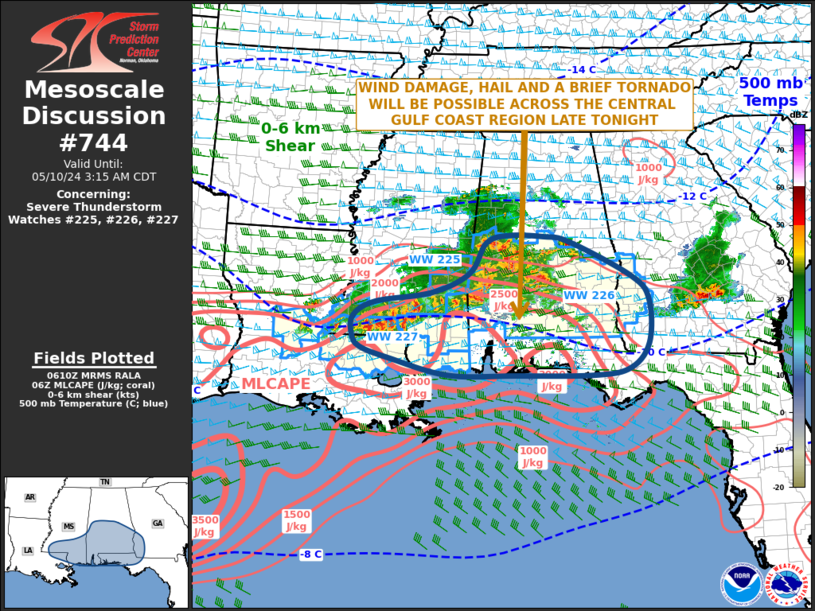
   SUMMARY...Wind damage, hail and a brief tornado will be possible as
   an MCS moves southeastward across the central Gulf Coast region late
   tonight. New weather watch issuance will likely need to be
   considered as the MCS approaches the southeastern edge of the
   ongoing watches.

   DISCUSSION...The latest mosaic radar imagery shows a well-developed
   MCS from south-central Alabama extending west-southwestward into
   southwest Mississippi. The MCS is located on the northern edge of a
   strongly unstable airmass centered over the central Gulf Coast.
   Across this airmass, MLCAPE is estimated by the RAP in the 2500 to
   3500 J/kg range. In addition, regional WSR-88D VWPs have 0-6 km
   shear near 50 knots which will be favorable for supercells and
   bowing line segments, in or ahead of the MCS. Wind damage will be
   likely along the more intense parts of the line. Also, the WSR-88D
   VWP in southeast Alabama has 0-3 km storm-relative helicity in the
   200 to 250 m2/s2 range. This should support an isolated tornado
   threat with supercells and with rotating cells embedded in the line.
   The threats should continue to move along the instability gradient,
   eventually affecting parts of far southern Mississippi, far southern
   Alabama and the Florida Panhandle. New weather watch issuance may be
   needed across this area late tonight.

   ..Broyles.. 05/10/2024

   ...Please see www.spc.noaa.gov for graphic product...

   ATTN...WFO...FFC...TAE...BMX...MOB...JAN...LIX...

   LAT...LON   30569021 30258888 30258739 30258563 30398479 30868437
               31708435 32178474 32848613 32958675 32988756 32838804
               32248841 31868926 31659055 31379104 31029106 30779088
               30569021
|
|
Top/All Mesoscale Discussions/Forecast Products/Home
|
|


