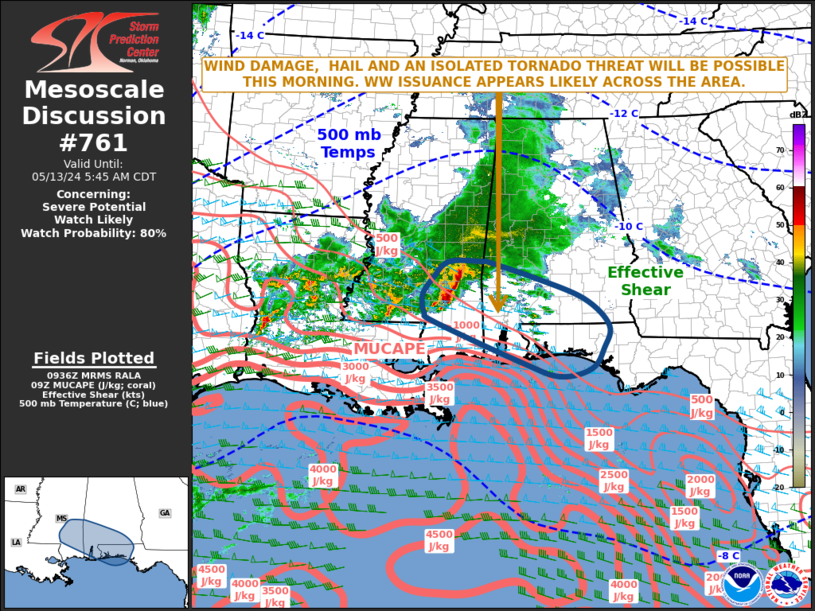
   Mesoscale Discussion 0761
   NWS Storm Prediction Center Norman OK
   0439 AM CDT Mon May 13 2024

   Areas affected...Southern Mississippi...Southern Alabama...Western
   Florida Panhandle

   Concerning...Severe potential...Watch likely

   Valid 130939Z - 131045Z

   Probability of Watch Issuance...80 percent

   SUMMARY...A wind damage, hail and an isolated tornado threat will be
   possible for several more hours, as a line segment moves
   east-southeastward from southern Mississippi into southern Alabama
   and the western Florida Panhandle. Weather watch issuance will
   likely be needed.

   DISCUSSION...The latest hi-resolution radar from Jackson, MS shows
   an organized line segment moving east-southwestward across southern
   Mississippi. This line is being supported by a shortwave trough,
   evident on water vapor imagery, and is located along a gradient of
   instability, where the RAP has MUCAPE in the 500 to 1000 J/kg range.
   Along this west-northwest to east-southeast corridor, regional
   WSR-88D VWPs and RAP forecast soundings have 0-6 km shear in the 60
   to 75 knot range. This should continue to be favorable for storm
   organization for several more hours. Wind damage will be possible
   along the leading edge of the line. In addition, the WSR-88 VWP at
   Fort Rucker, AL has 0-3 km storm-relative helicity around 350 m2/s2
   suggesting an isolated tornado threat will also be possible. The
   severe threat may increase along the leading edge of the line, if it
   can become more surface-based.

   ..Broyles/Guyer.. 05/13/2024

   ...Please see www.spc.noaa.gov for graphic product...

   ATTN...WFO...TAE...BMX...MOB...JAN...LIX...

   LAT...LON   32218844 32208921 31878958 31538980 31198975 31018952
               30238754 29968668 30128597 30528570 30968558 31488614
               31898725 32188824 32218844
|


 @NWSSPC