|
| Mesoscale Discussion 767 |
|
< Previous MD Next MD >
|
|
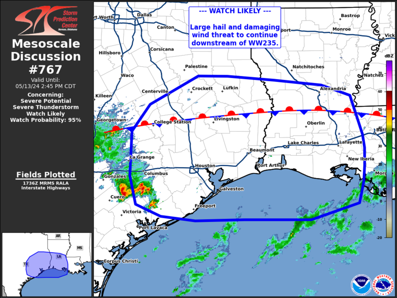
   Mesoscale Discussion 0767
   NWS Storm Prediction Center Norman OK
   1239 PM CDT Mon May 13 2024

   Areas affected...southern Texas into southwestern Louisiana

   Concerning...Severe potential...Severe Thunderstorm Watch likely

   Valid 131739Z - 131945Z

   Probability of Watch Issuance...95 percent

   SUMMARY...Severe threat to continue downstream of WW235. Downstream
   watch will likely be needed soon.

   DISCUSSION...A mix of clustered cells and supercell structures have
   been ongoing across portions of south-central Texas producing
   instances of quarter to half dollar size hail. Ahead of this
   activity, dew points are in the upper 70s to near 80 with MLCAPE
   around 3000-4000 J/kg. This, in combination with strong deep layer
   shear around 45-50 kts will continue to support supercells capable
   of very large hail (2-3.5 in). Trends suggest thunderstorms will
   gradually grow upscale while moving along a stalled front through
   the late afternoon/evening. This will lead to an increase in
   damaging wind threat, with potential for wind speeds 70+ mph and a
   tornado or two. A downstream watch will likely be needed to cover
   this threat.

   ..Thornton/Thompson.. 05/13/2024

   ...Please see www.spc.noaa.gov for graphic product...

   ATTN...WFO...JAN...LIX...LCH...SHV...HGX...FWD...EWX...

   LAT...LON   30499682 31059640 31649528 31639459 31569350 31449238
               31239172 30439144 30169141 29819142 29489145 29059155
               28739266 28749419 28719532 28799611 29029668 29599684
               30499682
|
|
Top/All Mesoscale Discussions/Forecast Products/Home
|
|


 @NWSSPC