|
| Mesoscale Discussion 791 |
|
< Previous MD Next MD >
|
|
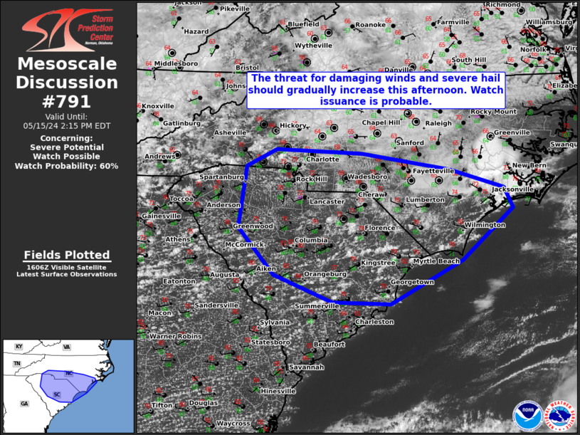
   Mesoscale Discussion 0791
   NWS Storm Prediction Center Norman OK
   1110 AM CDT Wed May 15 2024

   Areas affected...Portions of NC/SC

   Concerning...Severe potential...Watch possible

   Valid 151610Z - 151815Z

   Probability of Watch Issuance...60 percent

   SUMMARY...The threat for damaging winds and severe hail should
   gradually increase this afternoon. Watch issuance will probably be
   needed.

   DISCUSSION...16Z surface observations show a front draped east-west
   along and near the NC/SC border. Severe potential this afternoon
   will probably remain focused along and south of this boundary, where
   greater diurnal heating will occur. This heating of a moist
   low-level airmass is already supporting weak to locally moderate
   instability, with MLCAPE generally ranging 1000-2000 J/kg. A belt of
   enhanced mid-level flow associated with a weak upper trough over the
   OH/TN Valleys is present across the central into coastal Carolinas.
   Around 40-50 kt of deep-layer shear is being estimated by latest
   mesoanalysis, which may be a little high compared to recent VWPs
   across this region. Still, sufficient effective bulk shear will be
   present to support organized convection, including the potential for
   a few supercells. Isolated large hail generally in the 1-1.75 inch
   range will be possible with any persistent, discrete thunderstorms
   that can track eastward through the afternoon. Occasional
   severe/damaging winds of 55-70 mph also appear possible, especially
   if convection can develop into one or more small bowing clusters.
   This damaging wind potential may remain more focused along/near the
   front. Given expectations for the overall hail/wind threat to
   gradually increase through the afternoon, Severe Thunderstorm Watch
   issuance will probably be needed.

   ..Gleason/Thompson.. 05/15/2024

   ...Please see www.spc.noaa.gov for graphic product...

   ATTN...WFO...MHX...RAH...ILM...CHS...CAE...GSP...

   LAT...LON   33138031 33548139 34258204 35198189 35448134 35397978
               35137816 34867717 34557701 33777794 33117926 33138031
|
|
Top/All Mesoscale Discussions/Forecast Products/Home
|
|


 @NWSSPC