|
| Mesoscale Discussion 830 |
|
< Previous MD Next MD >
|
|
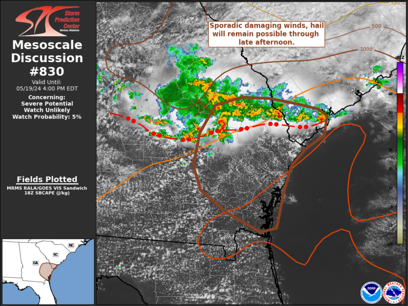
   Mesoscale Discussion 0830
   NWS Storm Prediction Center Norman OK
   0101 PM CDT Sun May 19 2024

   Areas affected...Southeast Georgia and far southern South Carolina

   Concerning...Severe potential...Watch unlikely

   Valid 191801Z - 192000Z

   Probability of Watch Issuance...5 percent

   SUMMARY...Sporadic damaging winds and severe hail will remain
   possible through the late afternoon hours as thunderstorms spread
   southward into southeast Georgia. Watch issuance is not expected.

   DISCUSSION...Scattered thunderstorms continue to develop in the
   vicinity of a weak upper-level disturbance that is slowly meandering
   southeastwards towards the GA coast. Although a consolidated cold
   pool has become established at this point (based on radar velocity
   data and surface observations), MRMS echo top data and GOES IR
   imagery have shown several intense updraft pulses within the last
   half hour, even behind the primary outflow boundary. This
   thunderstorm cluster is expected to slowly push southward into
   southeast GA through late afternoon. Weak deep-layer wind shear
   (20-25 knots) downstream will continue to limit the longevity and
   organization of the more robust updraft pulses; however, the
   thermodynamic environment is favorable for strong to severe
   downbursts given moderate SBCAPE (2500-3000 J/kg), steep low-level
   lapse rates, and theta-e deficits between 25-30 K. One such
   downburst has already been observed in southern SC and resulted in a
   68 mph wind gust. While winds of this magnitude should be fairly
   infrequent with these storms, damaging winds appear probable.
   Similarly, sporadic severe hail has been observed and will continue
   to be a threat given cool temperatures aloft and surface-based
   lifted indices between -8 to -10 K. Due to the short-lived nature of
   this activity, instances of severe wind/hail should be sufficiently
   sporadic to preclude the need for watch issuance.

   ..Moore/Hart.. 05/19/2024

   ...Please see www.spc.noaa.gov for graphic product...

   ATTN...WFO...CHS...JAX...FFC...

   LAT...LON   30768161 31048218 31388262 31738276 32218265 32618239
               32748192 32718144 32648097 32558061 32468046 32178051
               31988084 31738108 31448118 31168126 30948131 30838133
               30768161
|
|
Top/All Mesoscale Discussions/Forecast Products/Home
|
|


 @NWSSPC