|
| Mesoscale Discussion 833 |
|
< Previous MD Next MD >
|
|
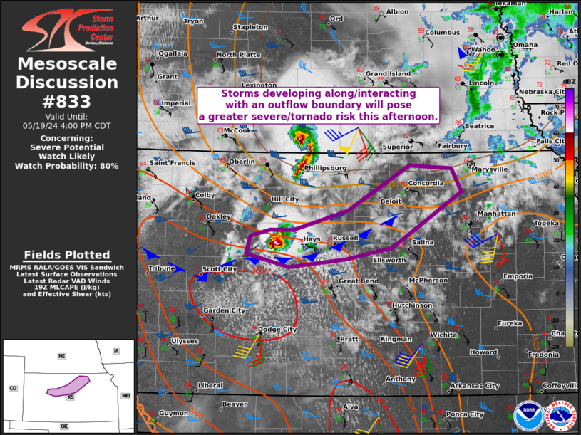
   Mesoscale Discussion 0833
   NWS Storm Prediction Center Norman OK
   0205 PM CDT Sun May 19 2024

   Areas affected...Parts of Central Kansas

   Concerning...Severe potential...Watch likely

   Valid 191905Z - 192100Z

   Probability of Watch Issuance...80 percent

   SUMMARY...A favorable mesoscale environment for severe weather,
   including tornadoes, will exist along an outflow boundary in central
   Kansas. Storm coverage may remain isolated at least in the short
   term. A watch is likely this afternoon.

   DISCUSSION...A storm has developed in Trego County. This development
   appears to have evolved out of elevated convective activity. This
   storm has not been overly organized per KGLD/KDDC radar imagery, but
   the environment along an outflow boundary continues to destabilize.
   The potential exists for this storm to become rooted at the surface.
   With surface heating occurring north of the outflow, MLCIN should
   steadily erode and not be overly prohibitive to storm maintenance.
   Low-level shear will be locally maximized near the outflow boundary.
   As such, any storm that can favorably interact with this boundary
   will have greater potential to produce a tornado as well as
   very-large hail. Additional storms could develop farther east, but
   this scenario is more uncertain. Some high-resolution guidance
   evolves this activity into a linear segment. Severe wind gusts would
   become a greater threat if that occurs.

   ..Wendt/Hart.. 05/19/2024

   ...Please see www.spc.noaa.gov for graphic product...

   ATTN...WFO...TOP...ICT...GID...DDC...GLD...

   LAT...LON   38699862 38589952 38740019 38960014 39049982 39059946
               39299860 39849761 39819695 39519679 38829789 38699862
|
|
Top/All Mesoscale Discussions/Forecast Products/Home
|
|


 @NWSSPC