|
| Mesoscale Discussion 840 |
|
< Previous MD Next MD >
|
|
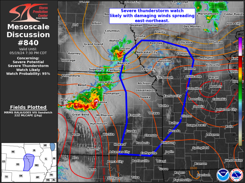
   Mesoscale Discussion 0840
   NWS Storm Prediction Center Norman OK
   0555 PM CDT Sun May 19 2024

   Areas affected...Eastern KS...far southeast NE...western
   MO...southwest IA

   Concerning...Severe potential...Severe Thunderstorm Watch likely

   Valid 192255Z - 200030Z

   Probability of Watch Issuance...95 percent

   SUMMARY...A developing MCS over central Kansas is expected to
   accelerate east-northeastward later this evening towards parts of
   the Mid to Lower Missouri Valley. Damaging winds from 70-90 mph will
   be the primary threat, most likely across eastern Kansas. A
   downstream severe thunderstorm watch will be needed.

   DISCUSSION...As alluded to in MCD 0839, increasingly widespread
   severe wind gusts are expected as multiple intense thunderstorm
   clusters over north-central to southwest KS consolidate by
   mid-evening. The leading cluster across north-central KS should
   spread into northeast KS initially, with additional low-level
   warm-advection-driven storms possible farther northeast across the
   Mid-MO Valley. Surface dew points are generally in the mid 50s to
   low 60s across northeast KS and southeast NE currently and this may
   mitigate eastward intensification in the near-term. But a plume of
   higher surface dew points exists both to the south, emanating north
   from OK, and farther east into central/northern MO. Eventual cluster
   consolidation will probably yield eastward acceleration later this
   evening with embedded bows spreading across at least eastern KS. A
   plume of substantial MLCIN that will increase after dusk across
   eastern OK and southeast KS, may result in the more prominent severe
   wind threat arcing east-northeastward in time.

   ..Grams/Smith.. 05/19/2024

   ...Please see www.spc.noaa.gov for graphic product...

   ATTN...WFO...SGF...DMX...EAX...OAX...TOP...ICT...

   LAT...LON   39859658 40619637 41179558 41169463 40899345 40459313
               38249378 37019512 37069656 38219623 39299628 39859658
|
|
Top/All Mesoscale Discussions/Forecast Products/Home
|
|


 @NWSSPC