|
| Mesoscale Discussion 847 |
|
< Previous MD Next MD >
|
|
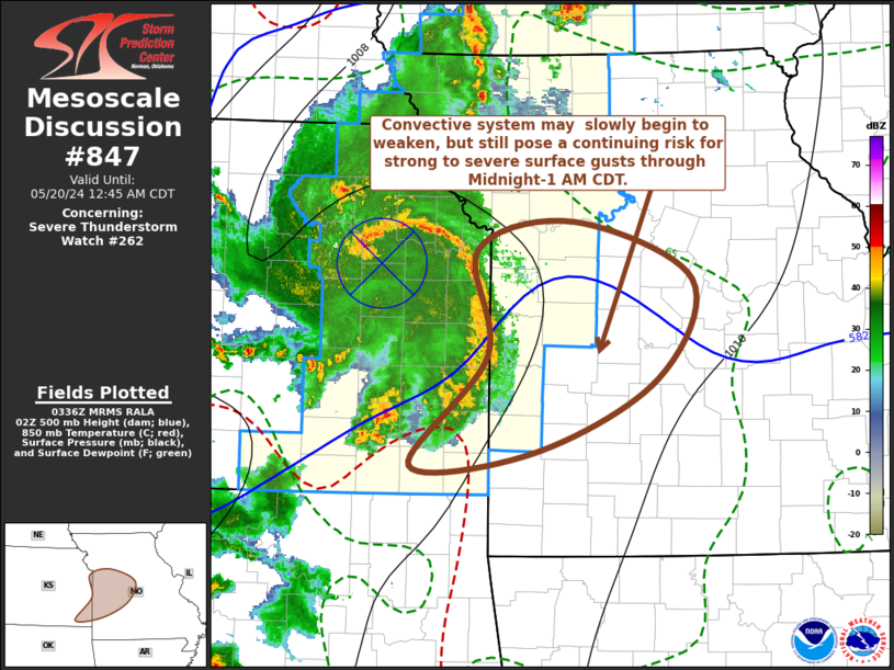
   Mesoscale Discussion 0847
   NWS Storm Prediction Center Norman OK
   1038 PM CDT Sun May 19 2024

   Areas affected...parts of western into central Missouri

   Concerning...Severe Thunderstorm Watch 262...

   Valid 200338Z - 200545Z

   The severe weather threat for Severe Thunderstorm Watch 262
   continues.

   SUMMARY...An organized cluster of thunderstorms may slowly begin to
   weaken, but probably will continue to pose a risk for strong to
   severe gusts across parts of the Kansas City metro and Missouri Lake
   of the Ozarks, into the Columbia and Jefferson City vicinities,
   through Midnight-1 AM CDT.  It is not certain that a new severe
   weather watch will be needed, but WW 262 could be locally extended
   into parts of central Missouri.

   DISCUSSION...A couple of lower/mid-tropospheric vortices have
   consolidated into one larger mesoscale convective circulation now
   passing near/south of the Topeka KS vicinity.  This feature remains
   well-defined, with a strong convectively generated surface cold pool
   (including 6-8 mb 2 hourly rises at 03Z) advancing across the
   Emporia and Chanute vicinities of east-central/southeastern Kansas.
   This feature may have reached peak intensity, but the apex of the
   evolving bow echo in radar reflectivities (and associated surface
   gust front) is still advancing eastward around 45-50 kt.  At this
   continued motion, it would spread across the Missouri Lake of the
   Ozarks area into Columbia and Jefferson City vicinities through
   05-06Z.  As it does, less unstable easterly low-level inflow may
   begin to weaken convection, but the risk for strong to severe gusts
   may be a bit slower to diminish.

   ..Kerr.. 05/20/2024

   ...Please see www.spc.noaa.gov for graphic product...

   ATTN...WFO...LSX...SGF...EAX...ICT...

   LAT...LON   38999474 39219374 38749251 37939288 37339415 37239543
               38139463 38999474
|
|
Top/All Mesoscale Discussions/Forecast Products/Home
|
|


 @NWSSPC