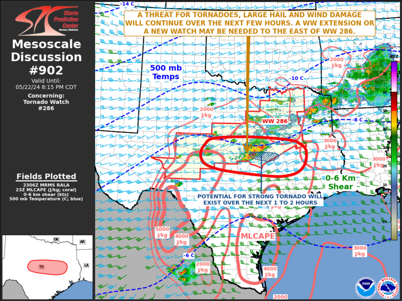
   Mesoscale Discussion 0902
   NWS Storm Prediction Center Norman OK
   0608 PM CDT Wed May 22 2024

   Areas affected...Central and East Texas

   Concerning...Tornado Watch 286...

   Valid 222308Z - 230115Z

   The severe weather threat for Tornado Watch 286 continues.

   SUMMARY...A threat for tornadoes, wind damage and isolated large
   hail will continue for a few more hours across parts of central and
   east Texas. As the severe threat moves toward the eastern edge of WW
   286, a local extension or new watch may be needed.

   DISCUSSION...The latest hi-resolution radar imagery from Fort Worth
   shows a small cluster of intense storms in the northern Texas Hill
   Country, in Lampasas, Coryell, and McLennan counties. Multiple
   supercells are ongoing, and one of the storms has had a persistent
   circulation. This cluster of storms will continue to move eastward
   into a corridor of extreme instability, where MLCAPE is estimated by
   the RAP in the 4500 to 5500 J/kg range. The nearest WSR-88D VWP,
   located at Granger, TX has 0-6 km shear of 45 to 50 knots, and 0-3
   km storm-relative helicity fluctuating in the 200 to 300 m2/s2 range
   over the last half hour. This environment should be favorable for
   supercells with a tornado threat. A strong tornado will be possible.
   Supercells will also be capable of isolated large hail. Hailstones
   of greater than 2 inches in diameter may accompany the most intense
   updrafts. Also, radar suggests that damaging winds will be likely
   near the strongest downdrafts, and winds could exceed 70 knots
   locally.

   ..Broyles.. 05/22/2024

   ...Please see www.spc.noaa.gov for graphic product...

   ATTN...WFO...HGX...FWD...EWX...SJT...

   LAT...LON   30629884 30829975 31080006 31370011 31669994 31919953
               31999788 31869614 31719559 31489529 31149528 30859538
               30599566 30459616 30449694 30629884
|


 @NWSSPC