|
| Mesoscale Discussion 909 |
|
< Previous MD Next MD >
|
|
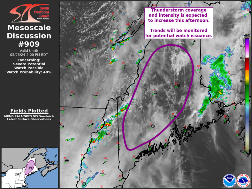
   Mesoscale Discussion 0909
   NWS Storm Prediction Center Norman OK
   1103 AM CDT Thu May 23 2024

   Areas affected...Much of Maine

   Concerning...Severe potential...Watch possible

   Valid 231603Z - 231800Z

   Probability of Watch Issuance...40 percent

   SUMMARY...Thunderstorm coverage and intensity is expected to
   increase this afternoon across as a line of storms moves across
   Maine. Overall severe coverage remain uncertain, but convective
   trends will be monitored for possible watch issuance.

   DISCUSSION...Visible satellite imagery reveals some scattered
   deepening cumulus across northern ME, beneath the high clouds
   spreading northeastward into the region. Thus far, these clouds
   remain fairly flat, but are indicative of airmass destabilization.
   This is occurring downstream of a line of convection over northern
   NH/far northwest ME. Expectation is that this line will continue
   eastward while the moist and buoyant downstream airmass continues to
   destabilize. This will likely support an increase in thunderstorm
   coverage and intensity within this line as it moves eastward across
   ME this afternoon.

   Surface temperatures are forecast to be in the low to mid 80s with
   dewpoints in the low 60s, helping to support moderate buoyancy
   around 1500 J/kg. Moderate westerly flow aloft already in place is
   expected to persist, and this combination of buoyancy and shear will
   likely support an organized convective line with occasionally strong
   updrafts. These storms coupled with steep low-level lapse rates
   could result in damaging gusts. Some hail is also possible within
   the stronger cores. Convective trends will be monitored for possible
   watch issuance.

   ..Mosier/Hart.. 05/23/2024

   ...Please see www.spc.noaa.gov for graphic product...

   ATTN...WFO...CAR...GYX...

   LAT...LON   45146843 44696888 44226957 43997014 43877053 44017071
               44587082 45197054 46566963 46716859 46146809 45146843
|
|
Top/All Mesoscale Discussions/Forecast Products/Home
|
|


 @NWSSPC