|
| Mesoscale Discussion 930 |
|
< Previous MD Next MD >
|

|
   Mesoscale Discussion 0930
   NWS Storm Prediction Center Norman OK
   1217 PM CDT Fri May 24 2024

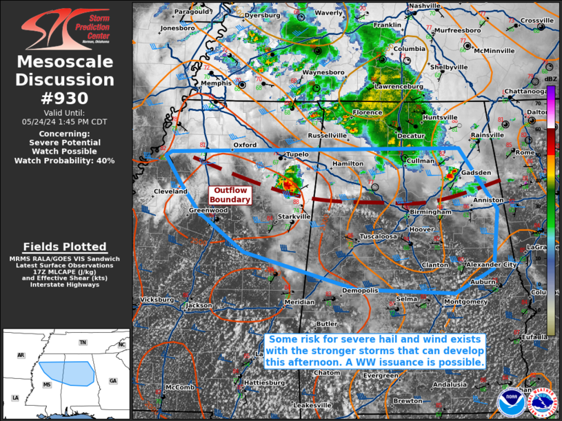
   Areas affected...portions of northern and central
   Mississippi...northern and central Alabama

   Concerning...Severe potential...Watch possible

   Valid 241717Z - 241845Z

   Probability of Watch Issuance...40 percent

   SUMMARY...At least isolated to potentially scattered instances of
   severe wind or hail may occur with the stronger storms across
   portions of the Southeast. Convective trends are being monitored for
   the need of a WW issuance.

   DISCUSSION...Scattered strong thunderstorms have recently developed
   along the leading edge of outflow and ahead of an MCV from a
   dissipating MCS across northern parts of MS and AL. Immediately
   ahead of the outflow boundary, strong diurnal heating is supporting
   boundary-layer deepening, with agitated CU already developing, and
   over 1500 J/kg MLCAPE evident via 17Z mesoanalysis. Over 50 kts of
   westerly 500 mb flow is contributing to strong unidirectional speed
   shear and modestly curved/elongated hodographs. Multicells should be
   the predominant mode of convection, though a transient supercell or
   two cannot be ruled out. Severe wind and hail may accompany the
   stronger storms. Coverage of severe storms is still somewhat
   uncertain, but convective trends are being monitored for the need of
   a WW issuance.

   ..Squitieri/Guyer.. 05/24/2024

   ...Please see www.spc.noaa.gov for graphic product...

   ATTN...WFO...BMX...HUN...MEG...JAN...

   LAT...LON   34398602 33608543 32848551 32538609 32588760 33068931
               33569001 33919028 34279052 34339043 34398602
|
|
Top/All Mesoscale Discussions/Forecast Products/Home
|
|


