|
| Mesoscale Discussion 936 |
|
< Previous MD Next MD >
|
|
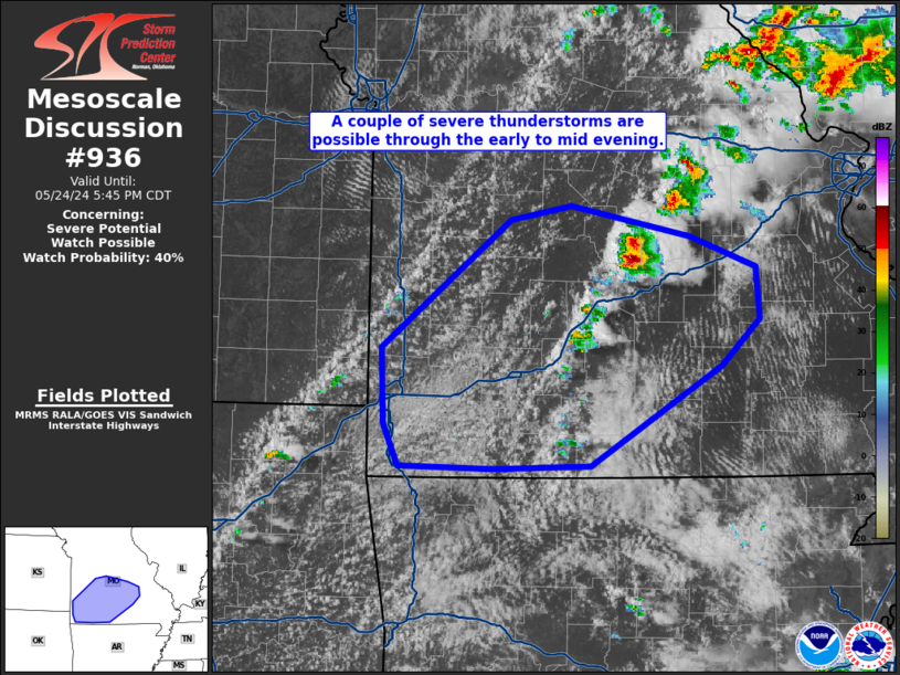
   Mesoscale Discussion 0936
   NWS Storm Prediction Center Norman OK
   0342 PM CDT Fri May 24 2024

   Areas affected...central and southwest MO

   Concerning...Severe potential...Watch possible

   Valid 242042Z - 242245Z

   Probability of Watch Issuance...40 percent

   SUMMARY...A couple of severe thunderstorms are possible over central
   and southwest MO through the early to mid evening.  Only isolated
   storm coverage is expected, lending uncertainty to the need for a
   severe thunderstorm watch.

   DISCUSSION...Visible satellite imagery shows a couple of storms
   developing within a pre-frontal confluence zone over central MO and
   agitated cumulus along the front/dryline over western MO and into
   far northeast OK.  Surface temperatures have warmed into the lower
   80s with dewpoints in the upper 60s to around 70 deg F.  Modifying
   the 18z Springfield, MO raob with 20z surface conditions, indicates
   4700 J/kg SBCAPE or MLCAPE around 3000 J/kg.  Per the 18z raob,
   moderate westerly flow gradually strengthening with height to 50 kt
   around 250 mb, will support storm organization.  Any robust updraft
   will potentially be capable of acquiring supercell characteristics.
   Large to very large hail will be the primary risk given the
   isolated/cellular character of the storm type.  Localized severe
   gusts could accompany any larger thunderstorm core.

   ..Smith/Guyer.. 05/24/2024

   ...Please see www.spc.noaa.gov for graphic product...

   ATTN...WFO...LSX...SGF...

   LAT...LON   37429450 38329335 38429280 38209175 37989116 37629113
               37299146 36579263 36559351 36589434 36889448 37429450
|
|
Top/All Mesoscale Discussions/Forecast Products/Home
|
|


 @NWSSPC