|
| Mesoscale Discussion 943 |
|
< Previous MD Next MD >
|
|
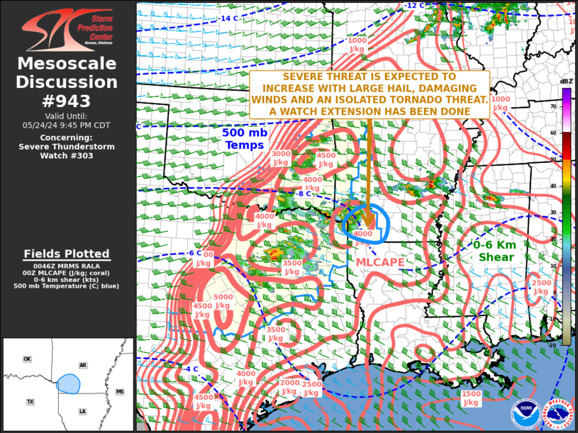
   Mesoscale Discussion 0943
   NWS Storm Prediction Center Norman OK
   0749 PM CDT Fri May 24 2024

   Areas affected...Southwestern Arkansas

   Concerning...Severe Thunderstorm Watch 303...

   Valid 250049Z - 250245Z

   The severe weather threat for Severe Thunderstorm Watch 303
   continues.

   SUMMARY...The severe threat is likely to increase across southern
   Arkansas. The primary threats will be large hail and wind damage,
   although a tornado could also occur. A watch extension in area has
   been done to account for the severe threat.

   DISCUSSION...The latest hi-resolution radar imagery from Shreveport,
   LA shows a cluster of strong to severe storms just to the northwest
   of Texarkana with at least one relatively intense supercell. Ahead
   of the cluster, surface dewpoints are in the mid to upper 70s, and
   MLCAPE is estimated by the RAP in the 3000 to 4000 J/kg range, and
   confirmed by the 00Z sounding at Shreveport. In addition, the latest
   WSR-88D VWP at Shreveport has 0-6 km shear near 45 knots with 0-3 km
   storm-relative helicity around 225 m2/s2. This environment suggests
   that supercells may be accompanied may have an isolated tornado
   threat. However, the greatest potential for severe will be
   associated with large hail and wind damage. Short-term models move
   the storms eastward across southern Arkansas and keep the threat
   going for a few more hours.

   ..Broyles/Thompson.. 05/25/2024

   ...Please see www.spc.noaa.gov for graphic product...

   ATTN...WFO...LZK...SHV...

   LAT...LON   33969358 33739401 33469417 33219405 33069357 32999311
               33149284 33629277 33979313 33969358
|
|
Top/All Mesoscale Discussions/Forecast Products/Home
|
|


 @NWSSPC