|
| Mesoscale Discussion 949 |
|
< Previous MD Next MD >
|

|
   Mesoscale Discussion 0949
   NWS Storm Prediction Center Norman OK
   1103 AM CDT Sat May 25 2024

   Areas affected...portions of eastern Alabama into southwestern
   Georgia

   Concerning...Severe potential...Watch possible

   Valid 251603Z - 251730Z

   Probability of Watch Issuance...60 percent

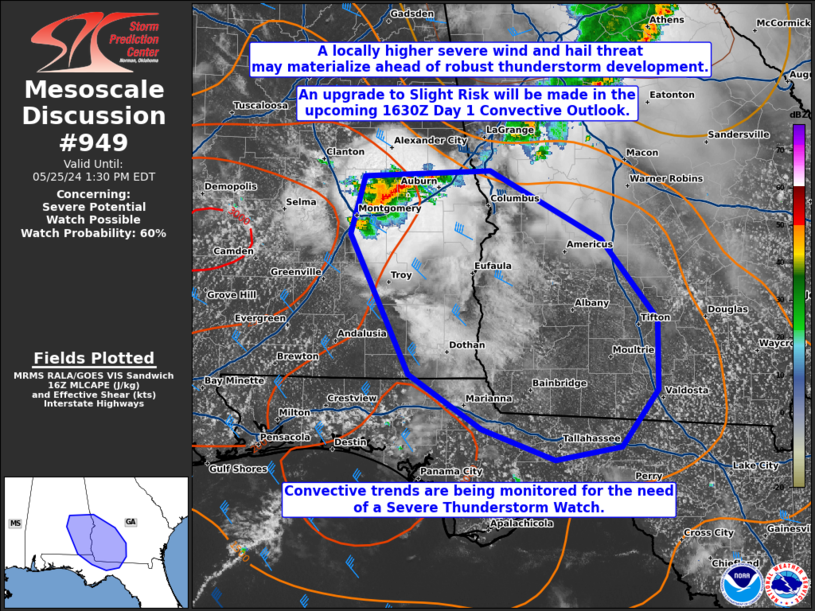
   SUMMARY...A locally higher severe threat may accompany a more robust
   cluster of thunderstorms moving southeast along the AL/GA border
   area. A categorical Slight Risk upgrade is anticipated for an
   increased severe wind/hail risk, with convective trends also being
   monitored for the need of a Severe Thunderstorm Watch issuance.

   DISCUSSION...An organized cluster of strong multicells and perhaps
   transient supercells has recently become established in east-central
   AL, and is poised to continue tracking southeastward early this
   afternoon. These storms are preceded by an unstable airmass (i.e.
   MLCAPE approaching 2000 J/kg), where a modest 500 mb speed max is
   also passing by. As such, a locally higher overlap of favorable
   buoyancy and modest deep-layer shear will promote at least a locally
   severe wind and hail threat. In response, a categorical upgrade to
   Slight Risk will be made in the 1630Z Day 1 Convective Outlook.
   Convective trends are also being monitored for the need of a Severe
   Thunderstorm Watch issuance pending greater storm coverage.

   ..Squitieri/Bunting.. 05/25/2024

   ...Please see www.spc.noaa.gov for graphic product...

   ATTN...WFO...FFC...TAE...BMX...MOB...

   LAT...LON   32698620 32748497 32178386 31488332 30898332 30428367
               30318433 30568504 31028576 32218635 32698620
|
|
Top/All Mesoscale Discussions/Forecast Products/Home
|
|


