|
| Mesoscale Discussion 955 |
|
< Previous MD Next MD >
|
|
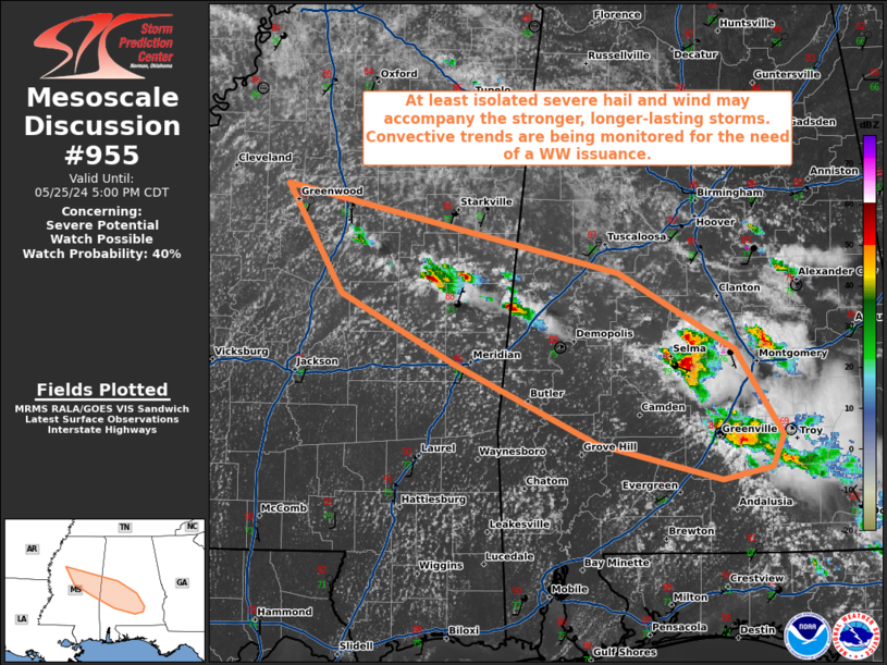
   Mesoscale Discussion 0955
   NWS Storm Prediction Center Norman OK
   0323 PM CDT Sat May 25 2024

   Areas affected...portions of central Mississippi into central
   Alabama

   Concerning...Severe potential...Watch possible

   Valid 252023Z - 252200Z

   Probability of Watch Issuance...40 percent

   SUMMARY...Strong thunderstorms may continue to increase in both
   coverage and intensity along residual outflow. Some of the stronger
   storms may produce damaging gusts and perhaps some large hail.
   Convective trends are being monitored for the need of a WW issuance.

   DISCUSSION...Several strong thunderstorms, including multicells and
   potential transient supercells, have been gradually intensifying
   along a diffuse outflow boundary left behind by earlier storms.
   These storms are ingesting a very buoyant airmass, characterized by
   90+/70+ F surface temperatures/dewpoints, where MLCAPE has reached
   3000 J/kg. Coinciding this strong instability are elongated
   hodographs and up to 40 kts of effective bulk shear, driven
   primarily by stronger mid-level flow. As such, these storms should
   continue to further intensify, potentially with damaging gusts and
   perhaps an instance or two of large hail. Convective trends are
   being monitored for the need of a WW issuance.

   ..Squitieri/Bunting.. 05/25/2024

   ...Please see www.spc.noaa.gov for graphic product...

   ATTN...WFO...BMX...MOB...JAN...

   LAT...LON   33639026 32998746 32458648 31838607 31618616 31518659
               31788764 32358884 32848980 33639026
|
|
Top/All Mesoscale Discussions/Forecast Products/Home
|
|


 @NWSSPC