Mesoscale Discussion 0983
NWS Storm Prediction Center Norman OK
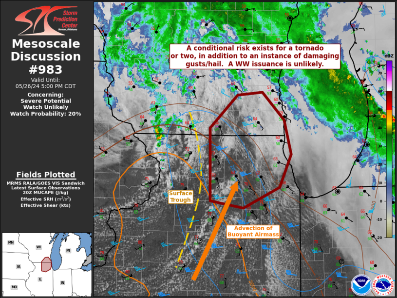
0326 PM CDT Sun May 26 2024
Areas affected...portions of far southeast Wisconsin into Northeast
Illinois
Concerning...Severe potential...Watch unlikely
Valid 262026Z - 262200Z
Probability of Watch Issuance...20 percent
SUMMARY...A conditional severe threat exists, including the
potential for a tornado or a couple bouts of strong wind gusts/hail.
Given the isolated and brief nature of the severe threat, a WW
issuance is not expected.
DISCUSSION...Airmass recovery is occurring within the warm sector
ahead of the surface low along the WI/IL border, with diurnal
heating supporting temperatures approaching the 70 F mark amid mid
60s F dewpoints. Ahead of a surface trough, where SBCAPE is
exceeding 1000 J/kg, surface wind remain backed, with substantial
veering and strengthening of the low-level wind field contributing
to elongated and curved hodographs. 20Z mesoanalysis show over 200
m2/s2 effective SRH in place. As such, any storm that can develop
ahead of the surface trough axis before surface winds veer may pose
a brief tornado threat, along with strong wind gusts and some hail.
Confidence in this conditional scenario is not overly high,
precluding a WW issuance at this time.
..Squitieri/Bunting.. 05/26/2024
...Please see www.spc.noaa.gov for graphic product...
ATTN...WFO...LOT...MKX...DVN...
LAT...LON 41588919 42598920 43068869 43098821 42718780 42228768
41768790 41488857 41588919
|


 @NWSSPC