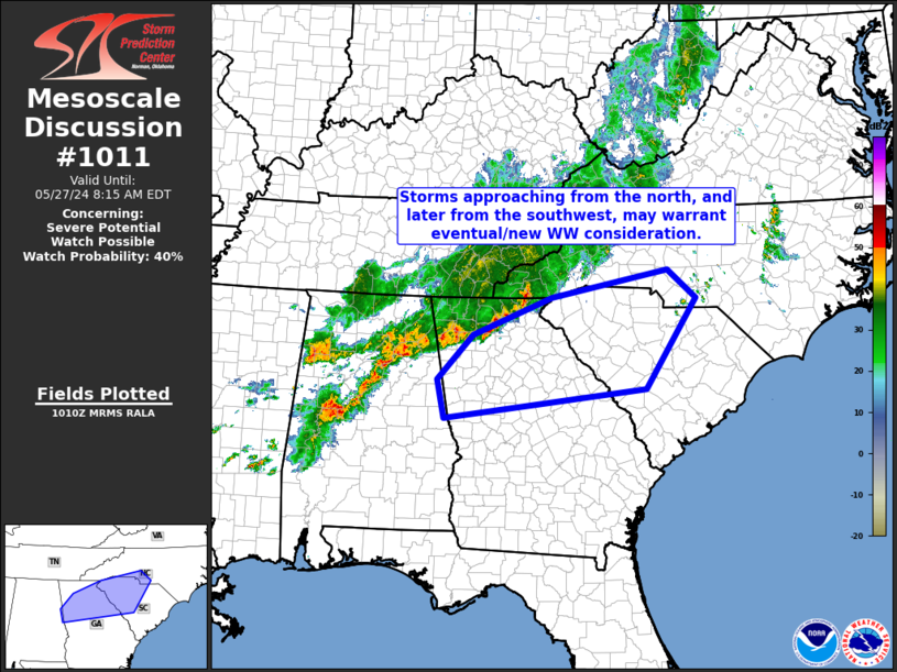
   Mesoscale Discussion 1011
   NWS Storm Prediction Center Norman OK
   0513 AM CDT Mon May 27 2024

   Areas affected...northern Georgia into South Carolina/southern North
   Carolina

   Concerning...Severe potential...Watch possible

   Valid 271013Z - 271215Z

   Probability of Watch Issuance...40 percent

   SUMMARY...Storms moving south-southeastward across northern Georgia,
   and east-northeastward across central Alabama, will likely persist
   for several hours.  Local/limited severe risk could prompt
   consideration for new WW issuance across northern Georgia and the
   western and central South Carolina vicinity.

   DISCUSSION...Latest radar loop shows an east-northeast to
   west-southwest band of strong thunderstorms moving southeastward
   across northern Georgia and northeastern Alabama at this time.
   Meanwhile, a second cluster of strong storms, south of the main
   convective band, is currently moving east-northeastward into/across
   central Alabama.  The downstream airmass across northern Georgia and
   into western South Carolina remains modestly unstable, likely
   sufficient to sustain storms over the next several hours.

   While severe risk should remain limited/local, greater instability
   -- possibly enhanced by the onset of some heating later this morning
   -- is indicated into central South Carolina and adjacent
   south-central North Carolina.  If convection can maintain some
   organization/intensity across northern Georgia and western South
   Carolina, some mid- to late-morning intensification could occur
   within the aforementioned, more-unstable airmass to the east.  Given
   these considerations, we will continue to monitor both the character
   and evolution of the ongoing storms, with an eye toward the possible
   need for new WW issuance east of WW 331 that is currently in effect
   across the central third of Alabama.

   ..Goss/Edwards.. 05/27/2024

   ...Please see www.spc.noaa.gov for graphic product...

   ATTN...WFO...RAH...CAE...GSP...FFC...BMX...

   LAT...LON   33578543 34348470 34998309 35468070 34988011 33428116
               32928528 33578543
|


 @NWSSPC