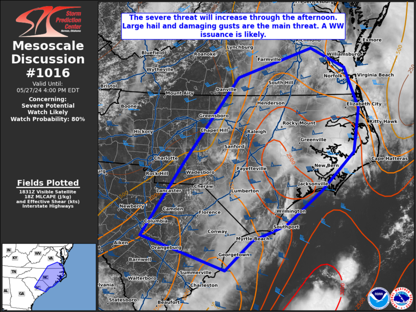
   Mesoscale Discussion 1016
   NWS Storm Prediction Center Norman OK
   0137 PM CDT Mon May 27 2024

   Areas affected...portions of northern South Carolina...eastern North
   Carolina...southeastern Virginia

   Concerning...Severe potential...Watch likely

   Valid 271837Z - 272000Z

   Probability of Watch Issuance...80 percent

   SUMMARY...The severe threat is increasing across portions of
   northeast SC into southeastern VA. Multicells, line segments, and
   supercells will likely develop this afternoon and pose a threat for
   large hail and damaging gusts. A tornado or two also cannot be ruled
   out. A WW issuance will likely be needed in the next hour or so.

   DISCUSSION...Strong diurnal heating is contributing to
   destabilization of the boundary layer, with surface temperatures
   rising into the 80s F amid upper 60s to low 70s F dewpoints,
   boosting MLCAPE over 2000 J/kg over many locales. As the 500 mb vort
   max over northern NC continues to progress east, and as MLCINH
   continues to erode, thunderstorms should develop in the next couple
   of hours, and increase in both coverage and intensity through the
   afternoon. A 35+ kt southwesterly low-level jet is overspreading the
   Carolinas, beneath a westerly 60+ kt 500 mb jet, contributing to
   modestly curved and elongated hodographs. As such, multicells, short
   line segments, and occasional supercells, will all be possible
   convective modes, accompanied by a large hail/damaging gust threat.
   Some forecast soundings show large enough low-level hodograph
   curvature to support an isolated tornado threat closer to the NC/VA
   coastline.

   Given the expected coverage of potential severe weather this
   afternoon, a WW issuance will likely be needed in the next hour or
   two.

   ..Squitieri/Guyer.. 05/27/2024

   ...Please see www.spc.noaa.gov for graphic product...

   ATTN...WFO...AKQ...MHX...RAH...ILM...RNK...CHS...CAE...GSP...

   LAT...LON   33808109 35218011 36897880 37467706 37087627 36277594
               35437607 34677684 34007768 33707848 33127912 33808109
|


 @NWSSPC