|
| Mesoscale Discussion 1060 |
|
< Previous MD Next MD >
|
|
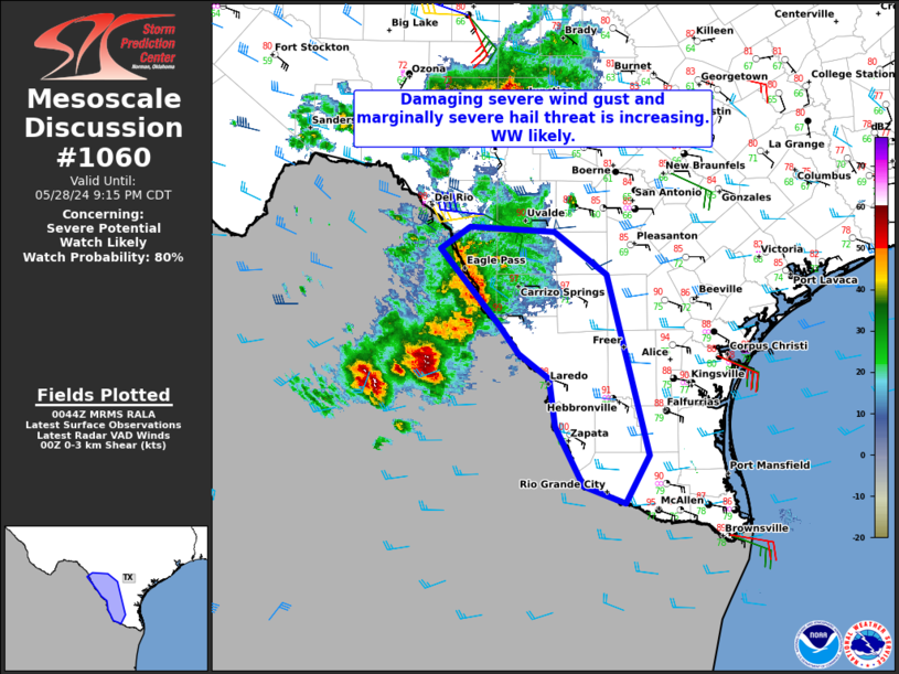
   Mesoscale Discussion 1060
   NWS Storm Prediction Center Norman OK
   0747 PM CDT Tue May 28 2024

   Areas affected...Portions of the Rio Grande Valley

   Concerning...Severe potential...Watch likely

   Valid 290047Z - 290215Z

   Probability of Watch Issuance...80 percent

   SUMMARY...Severe wind gusts near 60-70 mph and marginally severe
   hail will accompany a developing MCS through the late evening hours.

   DISCUSSION...Several robust updrafts, and a couple of supercells,
   will continue moving eastward off the higher terrain of Chihuahua
   Mexico. Cell mergers appear likely, and the downstream environment
   remains favorable for maintenance considering easterly surface winds
   around 15 to 20 kt. Convergence zone balance is anticipated between
   this surface flow and westerly 0-3 km shear vectors. In addition, a
   very unstable and undisturbed air mass remains in place across south
   Texas.

   ..Barnes/Smith.. 05/29/2024

   ...Please see www.spc.noaa.gov for graphic product...

   ATTN...WFO...CRP...EWX...BRO...

   LAT...LON   28910078 29130042 29099943 28639880 26759832 26259860
               26429908 27049942 27549949 27809984 28110007 28910078
|
|
Top/All Mesoscale Discussions/Forecast Products/Home
|
|


 @NWSSPC