|
| Mesoscale Discussion 1064 |
|
< Previous MD Next MD >
|
|
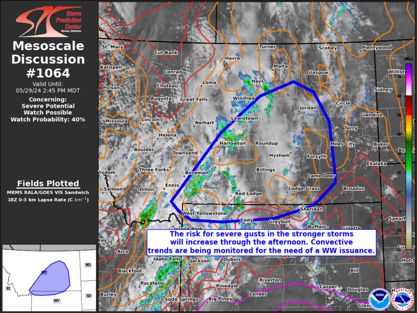
   Mesoscale Discussion 1064
   NWS Storm Prediction Center Norman OK
   0115 PM CDT Wed May 29 2024

   Areas affected...portions of extreme northern Wyoming into southern
   and central Montana

   Concerning...Severe potential...Watch possible

   Valid 291815Z - 292045Z

   Probability of Watch Issuance...40 percent

   SUMMARY...The threat for severe wind gusts will increase as storm
   coverage becomes greater this afternoon. The severe gust threat
   should initially be sparse in southwestern MT early this afternoon,
   but should become more abundant as storms approach eastern MT.
   Convective trends are being monitored for the more robust
   severe-gust threat and associated need for a WW issuance.

   DISCUSSION...Low-level lapse rates continue to steepen (i.e. the 7-8
   C/km range) as diurnal heating continues to support boundary layer
   mixing. A pronounced mid-level trough is overspreading the northern
   Rockies and tracking eastward, resulting in deep-layer ascent and
   accompanying potential for increased thunderstorm coverage through
   the afternoon. As thunderstorms strengthen and overspread the
   deepening boundary layer, the steep low-level lapse rates will
   foster severe gust potential. Severe gusts should initially remain
   isolated over southwestern MT. However, as the storms gradually move
   eastward amid deeper moisture and higher instability (i.e. 1000+
   J/kg MLCAPE), severe gusts could potentially become more common.
   Timing in a relatively greater uptick in potential severe wind gust
   production is not entirely certain. However, convective trends are
   being monitored to pinpoint when a greater-than-isolated severe gust
   threat may materialize, at which point a WW issuance may become
   necessary.

   ..Squitieri/Guyer.. 05/29/2024

   ...Please see www.spc.noaa.gov for graphic product...

   ATTN...WFO...BYZ...GGW...RIW...TFX...

   LAT...LON   45120619 44950650 44650785 44550966 44581072 44801119
               45031145 46800973 47700832 48050708 47780635 47040581
               45810566 45520564 45120619
|
|
Top/All Mesoscale Discussions/Forecast Products/Home
|
|


 @NWSSPC