|
| Mesoscale Discussion 1102 |
|
< Previous MD Next MD >
|
|
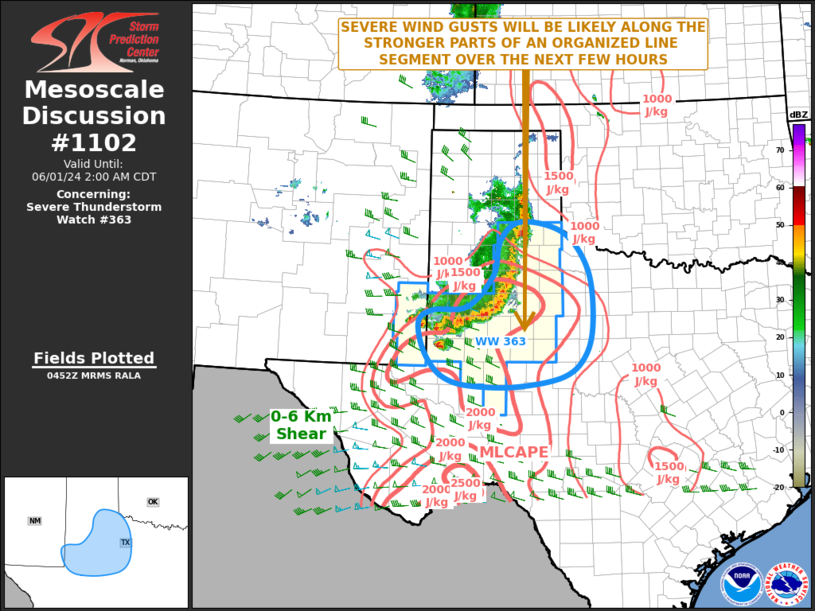
   Mesoscale Discussion 1102
   NWS Storm Prediction Center Norman OK
   1154 PM CDT Fri May 31 2024

   Areas affected...West and Northwest Texas

   Concerning...Severe Thunderstorm Watch 363...

   Valid 010454Z - 010700Z

   The severe weather threat for Severe Thunderstorm Watch 363
   continues.

   SUMMARY...A threat for severe wind gusts and hail will exist across
   parts of west Texas over the next few hours. The severe threat could
   impact areas to the southeast of WW 363, where a new weather watch,
   or extension in area could be needed.

   DISCUSSION...Mosaic radar imagery across west Texas shows a
   well-developed linear MCS located on the Caprock. This line of
   strong to severe storms is on the northern edge of a strongly
   unstable airmass, where the RAP has MLCAPE in the 2000 to 2500 J/kg
   range. This strong instability will likely help maintain convective
   intensity with the line over the next few hours. In addition, RAP
   forecast soundings ahead of the line have 0-6 km shear around 40
   knots, with a substantial amount of directional shear in the lowest
   3 km. This environment will likely continue to be favorable for a
   wind-damage threat associated with the stronger elements near the
   leading edge of the linear MCS. The strong instability and steep
   mid-level lapse rates, evident on forecast soundings, will also
   support a threat for isolated large hail.

   ..Broyles.. 06/01/2024

   ...Please see www.spc.noaa.gov for graphic product...

   ATTN...WFO...OUN...SJT...LUB...AMA...MAF...

   LAT...LON   33130214 33070290 32880324 32450320 32040298 31770264
               31630209 31610106 31809997 32229947 32909930 33859941
               34549996 34760092 34410140 33730156 33130214
|
|
Top/All Mesoscale Discussions/Forecast Products/Home
|
|


 @NWSSPC