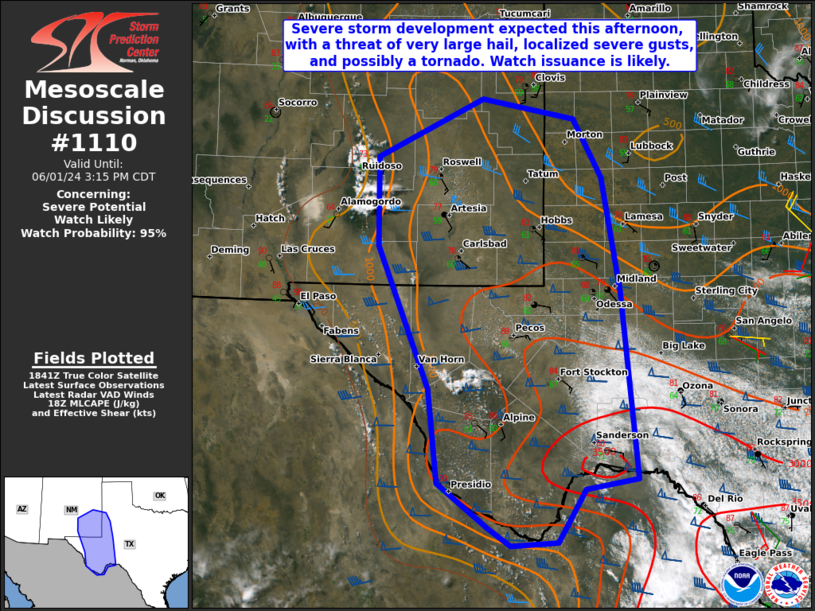
   Mesoscale Discussion 1110
   NWS Storm Prediction Center Norman OK
   0148 PM CDT Sat Jun 01 2024

   Areas affected...Parts of far west into southwest TX...southeast NM

   Concerning...Severe potential...Watch likely

   Valid 011848Z - 012015Z

   Probability of Watch Issuance...95 percent

   SUMMARY...Severe storm development is expected later this afternoon,
   with a threat of very large hail, localized severe gusts, and
   possibly a tornado. Watch issuance is likely by 3 PM CDT.

   DISCUSSION...Relatively strong heating is underway early this
   afternoon from southwest into far west TX and southeast NM.
   Low-level southeasterly flow will support continued moistening
   through the afternoon beneath steep midlevel lapse rates, resulting
   in moderate to strong destabilization. As CINH continues to weaken
   with time and a subtle subtropical shortwave trough approaches from
   the west, isolated to widely scattered thunderstorm development is
   expected by mid to late afternoon.

   Midlevel westerly flow is generally modest across the region, though
   somewhat stronger with southward extent into the Trans-Pecos and
   southern parts of the Permian Basin. A couple of supercells may
   evolve out of initial convection and move east-southeastward, with
   an attendant threat of large hail and localized severe gusts. The
   threat for very large hail (potentially 2 - 3.5 inches in diameter)
   may become maximized across parts of the Trans-Pecos region from 4-6
   PM CDT, when a supercell or two is expected to mature across that
   region. Finally, while low-level flow/shear will generally remain
   weak, a tornado cannot be ruled out, especially with any supercell
   that can propagate into the richer low-level moisture.

   Watch issuance is likely by 3 PM CDT, in response to the threats
   described above.

   ..Dean/Smith.. 06/01/2024

   ...Please see www.spc.noaa.gov for graphic product...

   ATTN...WFO...SJT...LUB...MAF...ABQ...EPZ...

   LAT...LON   30760467 32460537 33520539 34230391 33980264 33280225
               31910200 29690177 29570249 28950288 28900353 29120384
               29640454 30760467
|


 @NWSSPC