|
| Mesoscale Discussion 1139 |
|
< Previous MD Next MD >
|
|
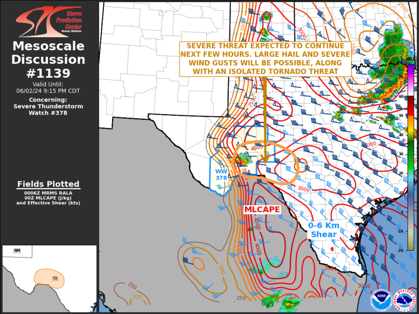
   Mesoscale Discussion 1139
   NWS Storm Prediction Center Norman OK
   0708 PM CDT Sun Jun 02 2024

   Areas affected...West and Southwest Texas

   Concerning...Severe Thunderstorm Watch 378...

   Valid 030008Z - 030215Z

   The severe weather threat for Severe Thunderstorm Watch 378
   continues.

   SUMMARY...The severe threat across west Texas is expected to
   continue over the next few hours. Large hail and severe wind gusts
   will be possible, along with an isolated tornado threat. The severe
   threat may affect areas of the far western Texas Hill Country later
   this evening, where a watch could be needed.

   DISCUSSION...The latest hi-resolution radar imagery from Midland, TX
   shows a small cluster of severe storms located to the northeast of
   Big Bend National Park. One supercell is ongoing in far eastern
   Brewster County. The airmass ahead of this cluster is strongly
   unstable, with the RAP analyzing MLCAPE in the 3000 to 4500 J/kg
   range. RAP forecast soundings in this area have 0-6 km shear near 50
   knots, with 700-500 mb lapse rates around 7.5 C/km. This environment
   will continue to be favorable for supercells with large hail.
   Hailstones greater than 2 inches in diameter, along with a few
   severe wind gusts will be possible. Forecast soundings also have 0-3
   km storm-relative helicity in the 150 to 200 m2/s2 range, suggesting
   that any tornado threat will remain isolated. The tornado threat may
   persist for a couple more hours. The cluster is expected to remain
   organized for at least a few more hours, as it moves to the east of
   WW 378. A new watch could become necessary if the cluster remains
   intense.

   ..Broyles.. 06/03/2024

   ...Please see www.spc.noaa.gov for graphic product...

   ATTN...WFO...EWX...SJT...MAF...

   LAT...LON   30930244 30450275 30030276 29740225 29680154 29560114
               29450062 29590013 30089994 30650024 31050137 30930244
|
|
Top/All Mesoscale Discussions/Forecast Products/Home
|
|


 @NWSSPC