|
| Mesoscale Discussion 1151 |
|
< Previous MD Next MD >
|
|
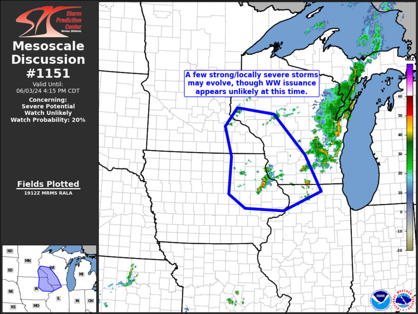
   Mesoscale Discussion 1151
   NWS Storm Prediction Center Norman OK
   0215 PM CDT Mon Jun 03 2024

   Areas affected...southeastern Minnesota and portions of eastern Iowa
   into western Wisconsin and northwestern Illinois

   Concerning...Severe potential...Watch unlikely

   Valid 031915Z - 032115Z

   Probability of Watch Issuance...20 percent

   SUMMARY...A few strong/locally severe storms are expected to evolve
   with time near the Upper Mississippi River Valley, and spread
   eastward/northeastward with time.  With the stronger storms expected
   to remain isolated, and magnitude of risk likely to remain limited,
   WW issuance is not currently anticipated.

   DISCUSSION...Latest radar loop shows storms developing from near the
   southeastern Minnesota/Wisconsin border/Mississippi River southward
   into northeastern Iowa.  The convection is occurring in an area of
   heating/destabilization that is ongoing west of remnant
   precipitation and associated cloud cover across central and eastern
   Wisconsin.  While continued heating -- which has pushed mixed-layer
   CAPE values to around 2000 J/kg -- will likely support additional
   storm development, the deep-layer wind field only modestly
   increases/veers with height.  This suggests mainly multicell
   organization of the stronger updrafts, likely limiting overall
   severe potential.  In addition, with storms tending to shift
   eastward/northeastward into the more rain- and cloud-cooled airmass
   with eastward extent, current expectations are that WW issuance may
   not be required.

   ..Goss/Smith.. 06/03/2024

   ...Please see www.spc.noaa.gov for graphic product...

   ATTN...WFO...GRB...LOT...MKX...DVN...ARX...MPX...DMX...

   LAT...LON   42189276 43409268 44369298 44969244 44779079 43468944
               42278875 41669039 41749205 42189276
|
|
Top/All Mesoscale Discussions/Forecast Products/Home
|
|


 @NWSSPC