|
| Mesoscale Discussion 1166 |
|
< Previous MD Next MD >
|
|
Mesoscale Discussion 1166
NWS Storm Prediction Center Norman OK
0526 PM CDT Tue Jun 04 2024
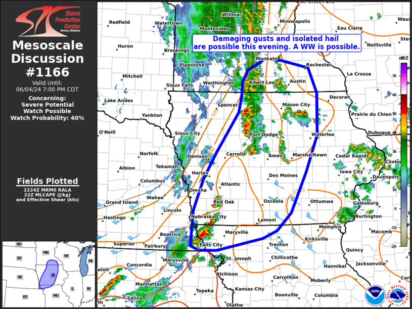
Areas affected...Portions of central IA far northern MO and southern
MN
Concerning...Severe potential...Watch possible
Valid 042226Z - 050000Z
Probability of Watch Issuance...40 percent
SUMMARY...Several clusters of thunderstorms appear likely to
increase in coverage and intensity this evening. While there remains
some uncertainty on the degree of storm organization, at least some
potential for damaging gusts and hail may warrant a WW.
DISCUSSION...As of 2220 UTC, regional radar analysis showed several
clusters of thunderstorms ongoing ahead of a slow moving cold front
associated with a broad mid-level trough stretching from southern MN
to northern MO. Mid to upper 60s F surface dewpoints are in place
over much of the Midwest, and diurnal heating has allowed
temperatures to warm into the low 80s F. Despite modest low and
mid-level lapse rates, moderate buoyancy (1000-1500 J/kg of MLCAPE)
is sufficient to support strong updrafts. Mid-level shear magnitudes
are not overly large with the stronger flow aloft displaced to the
north and east. Still area VADs show modestly curving hodographs and
effective shear of 25-30 kt over much of IA. Given the degree of
instability and forcing from the front/ developing cold pools, storm
organization into multicell clusters or short bowing segments is
possible. A few transient supercells structures are also possible
with the more discrete convection. With several measured gusts
already and the potential for more storms to mature this evening,
damaging gust and hail potential appears to increasing. Conditions
are being monitored for a possible weather watch.
..Lyons/Hart.. 06/04/2024
...Please see www.spc.noaa.gov for graphic product...
ATTN...WFO...DVN...ARX...MPX...DMX...EAX...OAX...
LAT...LON 40299375 40029507 40019560 40109582 40329582 40689578
40909576 41589549 42159512 43059446 43449438 43729436
43989420 44249366 44199321 44039238 43489212 42549213
41749247 40859293 40469333 40299375
|
|
Top/All Mesoscale Discussions/Forecast Products/Home
|
|


 @NWSSPC